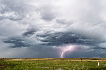
Explainer: What is thundersnow?
Emerging forensics suggests there may even be a human link to this bizarre phenomenon
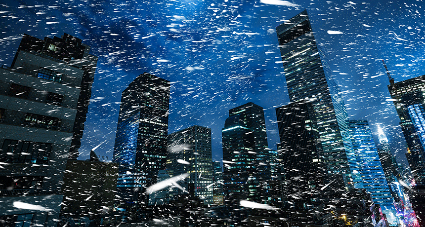
Tall structures, such as skyscrapers, radio towers and wind turbines, may create conditions that greatly up the chance of cloud-to-ground lightning during windy snowstorms.
palinchakjr/iStockphoto
Heavy snow can often create a peaceful setting. A blissful quiet may develop as snowflakes drape the landscape beneath a blanket of white. But occasionally, a sky-wide flash can disrupt this tranquility with a deafening, ear-splitting crash. That sound can echo, briefly, like gunshots. The ground may even shudder.
This is thundersnow.
To occur, the circumstances have to be exceptional. And unless it occurs almost directly overhead, you may never know it. The reason: Snow acts as a sound suppressor, muffling thunder and limiting the sound’s ability to bounce and spread.
Yet thundersnow appears to be getting a bit less rare.
For instance, a huge March 7 nor’easter snowstorm hit the Northeast states and New England earlier this week. And it was accompanied by numerous cracks of thunder. One bolt even struck New York’s tallest structure, the new 104-story World Trade Center building.
Two months earlier, another epidemic of thundersnow punctuated New England skies. It arrived shortly after daybreak on January 4, 2018. On that morning, a flurry of more than 30 flashes hit an otherwise quiet, wooded area in Montville, Conn. They occurred along a narrow band on the northwest side of rural Lake Konomoc.
Lightning mapping is accurate to within a few hundred meters (up to 1,000 feet). So it’s impossible to confirm with only those data what got struck. But there are two radio- and television-transmission towers in nearby Oakdale that soar some 316 and 367 meters (1,037 and 1,204 feet) into the sky. A limousine company — Liberty Limited — is right next to the property on which these towers sit. Angela Ried works for that limo company. And she confirms the towers were struck that day.
They “got struck at least four or five times,” she recalls. “It was pretty loud.” Though she knew at once it was lightning, she was surprised to hear it in winter. “I’ve worked here since ’93,” she notes, “and this is the first time I’ve ever seen thunder and lightning during a snowstorm.”
Her memory matches lightning reports logged by the National Weather Service.
Thundersnow also moved into Needham, Mass. Lightning was registered at sites near the WCVB-TV transmission towers. These structures rise some 395 meters (1,300 feet) into the air. They too sparked off about a dozen lightning strikes.
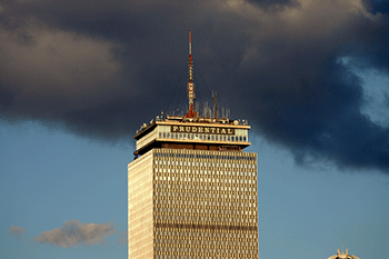
In nearby Boston, only one building got struck. It was the Prudential Tower, a 52-floor skyscraper with a rooftop spire topping 276 meters (906 feet). The mast broadcasts signals for multiple radio stations. “I heard it,” said Owen Anastas, of Boston. This particular strike, he notes, “happened around 11:30 during an incredible snow.”
The storm dumped a foot (one-third meter) or more of snow throughout a wide swath. And an estimated nine in every 10 lightning strikes in that storm struck man-made structures more than 250 meters (820 feet) tall. That raises the question: Are human structures playing some role in fostering thundersnow?
What makes thundersnow?
Thunderstorms usually form when warm air near the ground rises (because it is less dense than nearby masses of cold air). It’s the same reason a hot air balloon soars. And these conditions are why most boomers are spawned during spring and summer months.
The climbing air will rise several kilometers (miles) up, to a height where the temperature is below freezing. This can trigger a phenomenon called triboelectrification (Try-bo-ee-lek-trih-fih-KAY-shun). This word describes friction among air particles that causes a separation of electrical charge. It’s somewhat like rubbing a balloon against fabric so that the separated charge now allows the balloon to temporarily “stick” to the wall.
Air within the thunderstorm is very turbulent. This causes ice crystals to bump into each other. Through this process, they can gain or lose electrons. Ice crystals lose electrons, leaving them positively charged. Wetter precipitation gains electrons, making it negatively charged. When the charges build up enough — ZAP! An electric spark, or lightning, jumps between the two regions to balance out the charge.
To get this in the wintertime, however, is challenging. In the summer, pockets of air rise vertically to produce thunderstorms. That doesn’t really happen in the winter. Frigid-weather storms develop differently.
Two conflicting forces wage a battle that sends air on a “slantwise” path high into the sky. That means the air isn’t rising straight up and down, as in most thunderstorms. Thundersnow storms also do not usually form on the warm side of large, spiraling cyclones, as thunderstorms typically do. Instead, they develop in a weird spot – the colder backside of the storm system.
Because large storm systems oftentimes look like commas, that aggressive backlash is called the “comma head.” This is where cold air wraps in from the north.
Snowstorms can become super windy. This will happen because the lowest air pressure will occur at the center of the storm. It mimics a vacuum, pulling in air from its surroundings. Air spirals into the middle of storm systems like water swirling down a drain.
Or this is what usually happens.
But the January 2018 storm threw a meteorological curveball. It brought with it an extremely strong temperature gradient. Over the ocean waters off of Cape Cod, Mass., air temperatures soared to near 13° Celsius (55.4° Fahrenheit). Just 330 kilometers (205 miles) to the west, over land in Connecticut, it was 18 degrees C (23 degrees F) colder.
That extreme temperature contrast over such a narrow region generated a thermal wind. That’s when air flows from warm to cold regions.
Since cold air is denser; it sinks to the ground. Warm air from the ocean gets pulled in to replace it. That surface-hugging cold air undercuts the encroaching warm air. So the warm air now sloshes up that cold “surface” of air.
That warm air goes on to climb into the atmosphere because it has so much momentum. It’s like rolling a ball up a slide. Here, the slide is the surface of cold air. And the warm air is that ball rolling up that surface. Normally, the air wouldn’t take this path. It’s like bowling the ball up the slide, against the force of gravity.
It’s also fairly uncommon, which makes it tough to forecast. It is much easier to predict the conditions that tend to be associated with it, such as narrow bands of heavy snow.
Figuring out if, when and where lightning will strike within a snowstorm is a different story.
The National Lightning Detection Network is a commercial array of antennas across the United States. It monitors lightning strikes 24/7, all year long. But this network’s antennas will miss bolts that flash within clouds. That’s why the National Weather Service relies on public reports of thunder or lightning to track most thundersnow.
On rare occasions, as occurred earlier this winter, bolts may strike the ground. And when they do, these can be just as dangerous as strikes during a summer storm. They can cause damage, injury — even death. One bolt during a snowstorm on February 9, 2017, caused a house fire in Warwick, R.I. The bolt also zapped a nearby tree, blasting part of its trunk into the wall of that home,
The link to human activities
So what’s going on? Two Japanese researchers had some insights 24 years ago that they described in the Journal of Geophysical Research. Their paper reviewed decades’ worth of wintertime lightning strikes off the north coast of Japan. The pair used radar data and measurements from instruments used to measure electrical activity. From these data, clues emerged. It appeared that a key change takes place when low-topped winter thunderclouds mature.
Think of the cloud as a three-layer cake, with each layer having a different electrical charge. For shallow, low-topped winter thunderclouds, the charges in these layers are positive-negative-positive. The lower positive charge can appear at temperatures from 0 to -9° Celsius.
And where the lower layer has a net positive electric charge, that layer “is apparently capable of initiating ground flashes,” the paper noted.
So why did the 2018 New England storm clouds almost exclusively throw their lightning at tall towers?
It’s possible that these towers triggered the lightning by poking into the underside of clouds. In doing so, they take on this lower positive charge. They can now spark a bolt between the now-positive tower and the negative charge in the middle of the cloud above.
But that alone shouldn’t be enough to generate a bolt. After all, the electric fields in snowstorms are significantly smaller than those in summer thunderclouds.
However, those fields can be locally enhanced by pointy objects. Those points can focus a charge, boosting it 10-fold. And that may be enough to exceed the level required for an electric charge — or spark — to leap through the air. Once this happens, that spark can set off a rapid chain reaction.
With that, a lightning bolt is born.
The role of winds — high winds
But there’s a catch. Nature resists charges leaping through the air. So when a charge builds up on some object, the air tends to create a local region around it that has the opposite electric charge. This is known as a “space charge.”
Consider the tower. If a positive charge were to build up on the tip, a negative space charge should form around it. This would shield the tower tip from being struck by a bolt from a region in the middle layer of the cloud .
However, where the winds are strong enough, they can actually blow away this shielding space charge. That would leave the tower tip exposed, dramatically upping the odds of it triggering a lightning strike.
This was observed in 2011 during the Chicago thundersnow storm of February 1 and 2. Researchers Tom Warner, Timothy Lang and Walter Lyons observed winds of 29 kilometers per hour (18 miles per hour) during each cloud-to-ground lightning flash. They noted a whopping 93 percent of lightning strikes in the snowy region of the storm involved tall buildings or towers (including wind turbines).
During New England’s January thundersnow events, the top of each tower where a lightning bolt was recorded had also experienced high winds. Indeed, the minimum speed during every single flash exceeded 36 kilometers per hour (22.4 miles per hour). Moreover, the base of these storm clouds had been extremely low.
The minimum height at which moisture will condense, forming a cloud, is known as the “lifting condensation level.” In the case of the January storms, that level was around 275 meters (902 feet). And guess what: Each tower struck by lightning had been higher than that. So they would have poked into that lower positively charged region of the clouds.
And then there were the wind turbines
There was an exception, however. It was off the coast of Block Island, Rhode Island.
At first glance, it looked like 10 or so bolts of lightning had randomly struck the water. Data would later show that five wind turbines were out there. The turbines’ blades were mounted atop 30-meter (98.5-foot) pedestals. The turbines’ shafts were each 100 meters (328 feet) tall. And each turbine blade was 73.5 meters (214 feet) long. Their total height, then, would exceed 200 meters (656 feet) when a blade tip was pointed up.
That’s still, however, 75 meters (246 feet) short of the seemingly minimum height needed to pierce the cloud bottoms. But that doesn’t have to violate the rule because when clouds move over the ocean, they will encounter air with additional water vapor. And that will allow the minimum cloud-bottom height to fall somewhat. That means the blade tips indeed could have been immersed in the clouds’ lower positive charge.
Making predictions
Knowing this, can meteorologists forecast thundersnow in advance?
It appears so.
They can scan for conditions that would make possible such electrical light shows. For instance, something known as “ice crystal canting” often precedes winter lightning strikes. This term refers to the orientation of snowflakes. Those flakes and other ice crystals normally fall flatly horizontal, like a pancake on a griddle. But as an electric field builds in the base of a cloud, it can tilt (or cant) ice crystals into a vertical (up and down) orientation.
This shows up on radar as confused-looking banding. Knowing how to spot that radar signature could give forecasters a heads up to a field strong enough to produce thundersnow.
Figuring out which towers are tall enough to scrape the cloud base also could pinpoint likely strike candidates.
It’s entirely possible that without skyscrapers and other super-tall human-constructed towers, most thundersnow simply wouldn’t happen.
Using such knowledge, it might be possible one day soon to calculate the risk in a storm that any given tall structure will be struck by winter lightning.
The Weather Channel