Ancient ocean linked to supercontinent’s breakup
Shrinking Tethys Ocean could have ripped Pangaea apart
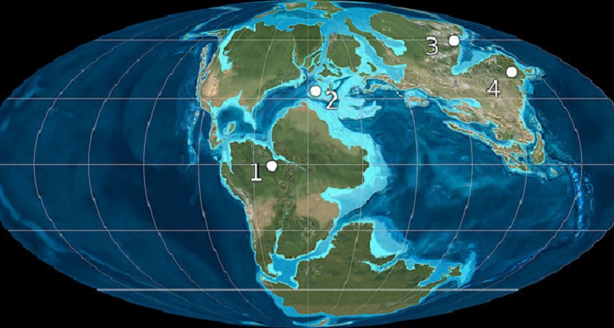
The compaction of the Tethys Ocean (lying between the landforms numbered 1, 3 and 4) may have torn apart the ancient Pangaea supercontinent, which once encompassed most of Earth's land.
Ron Blakey (CC BY-SA 3.0)
The breakup of an ancient supercontinent may have been an outside job. That’s the conclusion of a scientist who reexamined what tectonic plates were doing around 200 million years ago. Those plates carry the landmasses and seafloors as they move across Earth’s syrupy, bendable mantle. The scientist concludes that Pangaea — the supercontinent that once held most of Earth’s land — appears to have been ripped apart. And the shrinking of the ancestor of the Indian Ocean may have been all it took to do that, he argues in a newly published analysis.
The outer shell of the Earth is covered with more than a dozen tectonic plates. These pieces of the planet’s crust slowly grow, shrink and move. Their movement is one reason earthquakes can occur. It also is one reason the planet’s continents sit in different locations today than they did in the distant past.
Roughly 300 million years ago, there was no Africa or North America. All of Earth’s major landmasses were squashed into one huge supercontinent. Earth scientists refer to this mega-continent as Pangaea (pan-GEE-uh). Some 100 million years later, Pangaea began breaking apart. The Atlantic Ocean started to form between what would become North America and Africa.
Because Earth’s size didn’t change, the creation of a new ocean had to be balanced by the destruction of crust somewhere else. That occurred at sites known as subduction zones. These sites are where surface rock plunges into Earth’s interior and melts again.
Geoscientists have proposed two sites for where the subduction might have taken place when Pangaea began breaking apart. One is the ancestor of the Pacific Ocean. The other is Tethys — a forerunner of the modern Indian Ocean. Tethys crumpled as the early African and Eurasian continents drifted together. To the east, the western edge of North America may have steamrolled over the early Pacific Ocean.
Determining which ancient ocean allowed the Atlantic crust to form poses a challenge because of the planet’s shape, says Fraser Keppie. He is an Earth scientist at Nova Scotia’s Department of Energy in Halifax, Canada. The problem is that Earth is round. A sort of “conveyer belt” exists between newly forming and sinking sections of Earth’s crust. But if you cut up a globe and then lay it out flat, nothing lines up like it should. That makes it difficult to figure out where the conveyor belt starts and ends. Scientists need to see which areas are parallel to each other. But any flat map will distort this.
So Keppie tried another approach. A traditional flat map is anchored at the North and South poles. Keppie instead created a map that is circular and centered on a fixed point near Southern Europe. On that map, he plotted out the movement of the tectonic plates as Pangaea broke apart. Continents rotated around the fixed point like the swinging hands on a clock.
(Story continues below image)
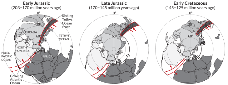
From this new perspective, the shrinking Tethys and the growing Atlantic both extend outward from the circle’s center, parallel to each other. The edge of the early Pacific sits along the circle’s edge. That ocean is perpendicular, not parallel, to the other two regions. By looking at this arrangement, the Atlantic’s growth clearly seems linked to the Tethys Ocean — not to the early Pacific, Keppie says. He reported his observations online February 27 in Geology.
“When I first saw this, I was really shocked,” he says. “It was absolutely apparent that the Atlantic and the Tethys are the compensation system, not the Atlantic and the Pacific.”
Keppie proposes that the Tethys Ocean was the driving force behind Pangaea’s breakup. Gravity pulled the crust underneath Tethys into a subduction zone. That yanked the crust on Pangaea’s Eurasian edge. If strong enough, this tug could have ripped the supercontinent apart between Africa and North America. That was a weak point. It was where two landmasses had stitched themselves together millions of years earlier.
This scenario is different from the currently accepted one for Pangaea’s breakup. That one holds that material from Earth’s interior sprung up along the boundary between North America and Africa. This would have pushed the two continents apart.
Keppie says that this theory makes less sense than his new one. Why? It relies on a big coincidence. It says the new crust material must have just bubbled up in the perfect spot, along one of Pangaea’s seams.
The new work signals that scientists may now have to rethink what led to Pangaea’s demise, says Stephen Johnston. He’s a geologist at Canada’s University of Victoria in British Columbia. “Everything we think we know about Pangaea is up in the air now,” he says. Johnston was not involved with the research.
Keppie’s work isn’t the final word on Pangaea’s breakup, Johnston notes. But it does make predictions that geologists can test. Scientists now can look for something like an ancient fault in the Pacific where two tectonic plates scraped together. “The great part about this work is that it’s clear, simple and testable,” Johnston says. ‘We can go out into the field and look at the rocks in light of his model and test it.”
Power Words
(for more about Power Words, click here)
continent (in geology) The huge land masses that sit upon tectonic plates. In modern times, there are six geologic continents: North America, South America, Eurasia, Africa, Australia and Antarctic.
crust (in geology) Earth’s outermost surface, usually made from dense, solid rock.
earthquake A sudden and sometimes violent shaking of the ground, sometimes causing great destruction, as a result of movements within Earth’s crust or of volcanic action.
Earth’s crust The outermost layer of Earth. It is relatively cold and brittle.
fault In geology, a fracture along which there is movement of part of Earth’s lithosphere.
geology The study of Earth’s physical structure and substance, its history and the processes that act on it. People who work in this field are known as geologists. Planetary geology is the science of studying the same things about other planets.
geoscience Any of a number of sciences, like geology or atmospheric science, concerned with better understanding the planet.
gravity The force that attracts anything with mass, or bulk, towards any other thing with mass. The more mass that something has, the greater its gravity.
landmass A continent, large island or any other continuous body of land.
Pangaea The supercontinent that existed from about 300 to 200 million years ago and was composed of all of the major continents seen today, squished together.
parallel An adjective that describes two things that are side by side and have the same distance between their parts. Even when extended into infinity, the two lines would never touch. In the word “all,” the final two letters are parallel lines.
perpendicular An adjective that describes two things that are situated approximately 90 degrees to each other. In the letter “T,” the top line of the letter is perpendicular to the bottom line.
planet A celestial object that orbits a star, is big enough for gravity to have squashed it into a roundish ball and it must have cleared other objects out of the way in its orbital neighborhood. To accomplish the third feat, it must be big enough to pull neighboring objects into the planet itself or to sling-shot them around the planet and off into outer space. Astronomers of the International Astronomical Union (IAU) created this three-part scientific definition of a planet in August 2006 to determine Pluto’s status. Based on that definition, IAU ruled that Pluto did not qualify. The solar system now consists of eight planets: Mercury, Venus, Earth, Mars, Jupiter, Saturn, Uranus and Neptune.
subduct (verb) or subduction (noun) The process by which tectonic plates sink or slide back from Earth’s outer layer into its middle layer, called the mantle.
subduction zone A large fault where one tectonic plate sinks beneath another as they collide. Subduction zones usually have a deep trench along the top.
tectonic plates The gigantic slabs — some spanning thousands of kilometers (or miles) across — that make up Earth’s outer layer.
Tethys Ocean An ancient sea.


