A natural ‘cathedral’ lurks deep under Antarctic ice
Almost as tall as the Empire State Building, it offers a window into subglacial secrets

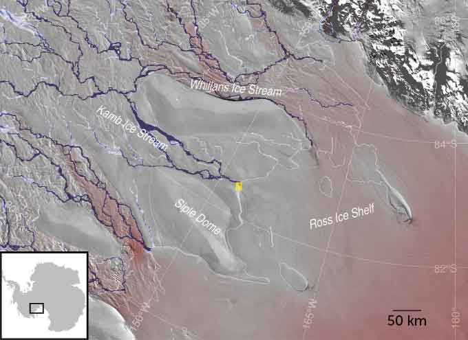
Using ice-penetrating radar, scientists discovered a massive hidden cavern beneath the lower Kamb Ice Stream in West Antarctica. A subglacial river melted the ice above it, carving out the enormous structure.
H. HORGAN
The coastal plain of the Kamb Ice Stream hardly seems like a coast at all. Some 800 kilometers (500 miles) from the South Pole, this glacier is oozing slowly off the coast of West Antarctica. From atop it, you see nothing but flat white extending in every direction. As this conveyor belt of ice flows out beyond the coast, it forms a floating shelf. That shelf extends hundreds of kilometers (miles) out to sea.
But this flat, boring landscape hides a secret.
Beneath its roughly 700 meters (2,300 feet) of ice sits a vast, muddy marsh. Through it meanders a river that eventually empties into the ocean. Along the way, that river has been carving a massive cavern into the ice above.
This cathedral-like structure is full of water. And it’s huge. It is 10 kilometers (6.2 miles) long and nearly tall enough for the Empire State Building to stand inside.
Until recently, no human had ever seen inside this cavern. But in late 2021, scientists from New Zealand melted a narrow hole through its icy roof. On December 29 of that year, they lowered a camera through the hole and got the first peek into this water-filled space.
Craig Stevens will always remember his first look. As a camera traveled down the borehole, a computer screen showed a hypnotic view of icy walls. They looked like a giant frozen wormhole. Around 500 meters (1,650 feet) down, the walls suddenly widened and a black void appeared. The camera had reached the top of the water-filled Kamb ice cavern.
Stevens stared as the camera’s floodlights raked across delicate crests and waves etched into the cavern’s icy ceiling. They resembled the dreamy ripples that might take thousands of years to form in a limestone cave. Stirred up by rising currents, bits of reflective silt drifted like snowflakes through the cavern’s water.

Stevens is an oceanographer. He works for New Zealand’s National Institute of Water and Atmospheric Research in Wellington. The video seemed to show “the interior of a cathedral,” he says. A cathedral of ice.
“It really is otherworldly under there,” says Huw Horgan. He’s a glaciologist who led the drilling expedition. Back in 2021, he worked for Victoria University of Wellington, in New Zealand. (This year, he moved to ETH Zurich, in Switzerland.) Horgan had spent seven years preparing for this day. Once the hole was open, he, Stevens and the rest of their team would spend another two weeks sending instruments into it.
The cavern offers a window onto a major subglacial river. That river flows beneath the ice on its way to the ocean. In some ways, it’s like an artery — think of the big artery in your neck. By listening to it, scientists can take the pulse of the ice sheet. They can eavesdrop on the private life of the ice, which is changing rapidly as the climate warms.
Rivers running uphill
Pulses in the flow of the river point to powerful floods that occasionally gush beneath the glacier. Those floods mark the filling and emptying of hidden lakes.
Those lakes sit under hundreds of meters of ice, many kilometers upstream. By monitoring a river’s flow, scientists can see these subglacial lakes shift from one place to another — or perhaps entirely disappear (see sidebar).
Roughly 98 percent of Antarctica is covered in glacial ice. Its thickness ranges from a few hundred meters to nearly five kilometers (three miles). Scientists had long believed that a thin film of liquid water sits beneath much of this ice. That water comes from the melting of ice on the glacier’s underbelly. That happens as heat seeps into the ice from deep inside the Earth. The rate of that melt is slow — several penny-thicknesses a year.
In 2007, Helen Amanda Fricker reported that the meltwater can collect, forming large subglacial lakes. At times, she found, they can overflow, unloading huge floods of water.
Fricker is a glaciologist at the Scripps Institution of Oceanography in La Jolla, Calif. Ice sitting above a lake, she noticed, rises as the lake fills, then falls as it empties. To measure this up-and-down motion, she analyzed data from satellites. The spacecraft shine laser beams onto the ice, then time how long it takes that light to reflect back up. The ice can move up and down by as much as 10 meters (about 33 feet) over a couple of years, she found. This method allowed her to map the locations of lakes under the ice.
More than 600 lakes have now been mapped under Antarctic glaciers. A couple dozen sit under the Kamb Ice Stream and neighboring glaciers.
These lakes have generated great interest. Biologists expected them to harbor life. And in 2013, a U.S. team found plenty in one lake that Fricker had discovered. Called Lake Whillans, it sits beneath 800 meters (a half mile) of ice, just south of the Kamb Ice Stream. Its water was teeming with single-celled microbes — some 130,000 per milliliter (fifth of a teaspoon) of water, scientists found.
Horgan had helped map Lake Whillans with ice-penetrating radar. But by the time the lake was drilled, he and others were also becoming interested in the rivers flowing under the ice.
Finding those rivers was hard. We normally expect rivers to flow downhill. But in Antarctica, the weight of ice pressing down on a river also influences its flow. So beneath glaciers, water flows from places where the overlying ice is thick (and the pressure high) to spots where the ice is thinner (and the pressure lower). This means some subglacial rivers will actually run uphill!
Exploring a hidden world with radar
In 2015, a lucky clue led Horgan to one such river.
While looking at a satellite photo of the Kamb Ice Stream, he noticed a dark spot. It marked a long, shallow groove on the surface of the ice. Horgan wondered if the ice sagged there because it was being melted from below. That groove might mark a river flowing toward the ocean.
But he did not grasp the sheer size of what lay beneath the ice there — until December 2019. That’s when he visited with Arran Whiteford, a PhD student.
The ice here is generally quite flat. So the surface groove was obvious to Whiteford when he arrived. It slanted no more dramatically than a rolling cornfield in Iowa. Yet in contrast to the surrounding ice, he recalls, it “looked like this massive chasm.”
For 10 days, Whiteford mapped the buried river channel using ice-penetrating radar. Horgan and another graduate student helped.
It was tedious. For up to eight or 12 hours a day, they towed the radar behind a snowmobile. It passed along a series of straight lines that crisscrossed the groove. The transmitter kept firing radar waves into the ice. An antenna picked up the waves reflecting off the bottom of the ice.
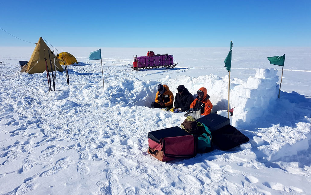
At night, the researchers huddled in a tent looking at the radar traces. Their data painted a dramatic picture.
Based on the size of the surface groove, the researchers expected the river channel on the bottom to cut 10 or 20 meters (33 to 66 feet) up into the ice. But it was larger. Much larger.
Below their boots sat a vast, water-filled passage with steep sides. They had discovered the Kamb ice cavern. It was like a train tunnel — but really big. It cut halfway through the overlying ice, to a height of 350 meters (more than 1,100 feet). It gaped 200 meters (650 feet) to a kilometer (3,280 feet) wide. And it really did resemble a river, says Whiteford, as “it kind of meanders downstream.”
The cavern’s size and shape
This 3-D illustration shows the shape of the Kamb ice cavern, based on the radar traces that Whiteford and Horgan collected in 2019. As the cavern lengthens further inland each year, it is following the meandering course of a subglacial river.

An upside-down waterfall melts the ice
Once back in New Zealand, Whiteford examined old satellite images. These, too, showed the surface groove that marked the cavern below. That cavern had started forming at least 35 years earlier, the images showed.
Far below the ice, it began as a short blip where the mouth of the river pours into the sea. Over decades, the cavern got longer. It followed the path of the river, reaching ever further upstream and inland.
Late last year, Whiteford and Horgan reported their findings in the Journal of Geophysical Research: Earth Surface. In it, they laid out their theory of how the cavern formed.
The river’s water is probably less than 0.1 degree Celsius (0.18 degree Fahrenheit) above freezing. That’s not warm enough to melt much ice. So Horgan believes that to erode the ice and form this cavern, the river has been stirring up warmer ocean water at its mouth.
These rivers can exert really powerful mixing forces, says Christine Dow. She’s a glaciologist at the University of Waterloo in Ontario, Canada. As they empty into the ocean, some of these rivers are moving up to two meters (6.6 feet) per second, she calculates. That’s as fast as a whitewater river.
The subglacial river contains much less salt than seawater. So it’s far less dense. As the river water enters the ocean, it rises quickly against the upward-slanting ceiling of ice. As it rises, it pulls turbulent swirls of ocean water up with it. “I think of it as an upside-down waterfall,” says Dow. “It’s bringing up this really warm ocean water to melt the base of the [glacier].”
The ice is melting quickly there — some 35 meters (115 feet) per year, Whiteford and Horgan estimate. And they think the canyon is still growing. Fueled by intruding ocean water, it is burrowing further upstream along the river’s path.
Mapping the cavern with radar was just the first step for Horgan. “We are almost prospecting,” he says. “We are looking for scientific targets beneath ice sheets.” In late 2021 he returned. Now, with a larger team, he was intent on drilling into the cavern.
Entering the cathedral
On December 4, 2021, two tractors reached the spot where Horgan and Whiteford had visited. These caterpillar-treaded PistenBullys had traveled 16 days from New Zealand’s Scott Base, on the edge of the continent. They towed a convoy of sleds across 1,000 kilometers (600 miles) of floating ice. Packed into those sleds were 90 metric tons of food, fuel and scientific gear.
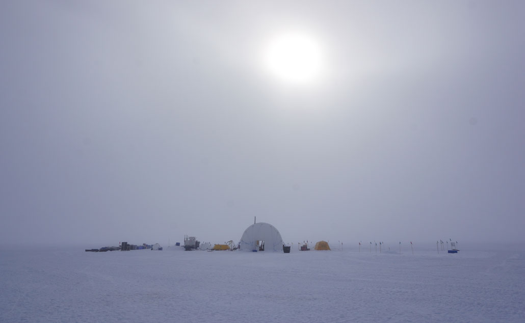
The convoy lumbered to the upstream end of the surface groove. There, workers erected a huge tent. Inside, they assembled water heaters, pumps and a kilometer-long length of hose. Together, these made up a hot water drill.
With it, they melted 54 tons of snow. They jetted this now-hot water down through the hose and into the ice. This bored a narrow hole no wider than a dinner plate into the ice. At 500 meters down, that hole reached the cavern.
On December 29, the researchers lowered a camera down that hole. It displayed the massive ice cavern’s rippled ceiling. But that was only the first of many exciting moments. After descending past the ceiling, the camera traveled another 242 meters (roughly 800 feet) through dark, sunless water to the muddy river bed.
And what now came into view astonished them.
Dozens of orange shapes darted back and forth through the camera’s lights. They were later identified as amphipods — shrimp-like crustaceans. Seeing them was “just complete shock,” says Horgan. No one is certain how these animals are surviving in an isolated nook, 500 kilometers (more than 300 miles) from the nearest sunlit ocean.
In the days that followed, Stevens lowered several instruments to measure the water’s temperature, saltiness and currents. These data seemed to confirm that the subglacial river is melting the ice by stirring up seawater.
Later, Gavin Dunbar plucked several cylinders of mud from the floor of the cavern. At the Victoria University of Wellington, he specializes in studying aquatic sediments. And his samples produced another big surprise.
The ice sheet’s hidden pulse
Dunbar had viewed many mud cores from the seafloors around Antarctica. They always contain a jumbled mix of mud, sand and gravel. That jumble would have developed during past ice ages as glaciers plowed across the seafloor. But the cavern floor here looked different. It contained alternating layers of chunky gravel and fine mud.
Dunbar has seen this same pattern in steep seafloor canyons off the coast of New Zealand. Landslides occasionally sweep down those canyons. Each landslide leaves a single chunky layer.
Between landslides, fine mud settles in.
Dunbar now believes something similar happens at the Kamb ice cavern. River floods may flush through now and then — the same type that Fricker detected with satellite data in 2007.
One flood might have passed through the cavern 10 years ago. Satellite signals showed that a small lake 20 kilometers (12 miles) upstream of the cavern spilled its contents. An estimated 60 million cubic meters of water gushed downstream. That’s enough to fill 24,000 Olympic-sized swimming pools!
Studying these floods and sediment layers could help scientists understand how the subglacial landscape changes over time. In fact, a recent discovery suggests that subglacial lakes can shift around quite a bit.
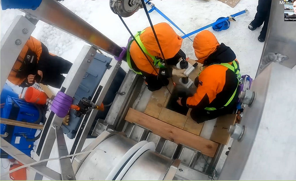
As people packed up camp at Kamb on January 11, 2022, workers widened the borehole. Then Stevens and his colleagues put on climbing harnesses, clipped into safety ropes and approached the hole one last time to lower a series of sensors.
These devices are continuing to measure the water’s temperature, salinity and currents. A cable brings those data to the surface. There, a transmitter beams them to New Zealand. Horgan and Stevens hope that in this way, they can learn even more about this hidden world.
“That would just be outstanding,” Horgan says. With radar, he can only see these rivers and lakes dimly. Finally, he says, “we’ve [been able] to stand at a river mouth and observe it.” And with luck, future data might even reveal a subglacial flood rushing through the cavern.


