New research may alter what we know about how tornadoes form
As the climate changes, twister behavior on the ground is changing, as well
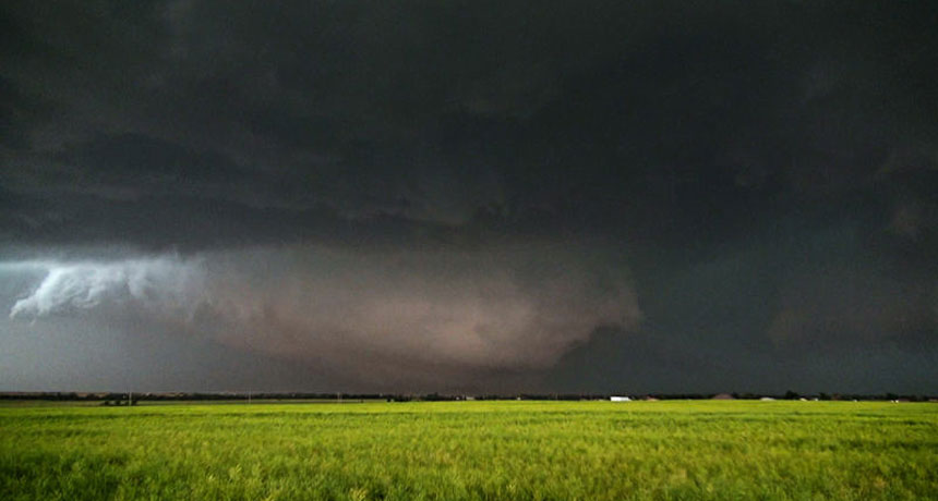
Scientists are rethinking how tornadoes form thanks in part to radar data and images of this tornado that struck El Reno, Okla., on May 31, 2013.
Nick Nolte/Wikimedia Commons (CC-BY-SA 3.0)
WASHINGTON, D.C. — Tornadoes might form from the ground up, rather than the top down.
That could seem unexpected. Many people picture tornadoes forming from funnel clouds that eventually extend to the ground, said Jana Houser. She spoke December 13 in a news conference, here, at the American Geophysical Union fall meeting. Houser is an atmospheric scientist at the University of Ohio in Athens. She and her colleagues have new data that upend this “top-down” idea of how tornadoes form.
Understanding how tornadoes form is important. That’s especially true in the United States, where the storms seem to be getting more intense.
Thunderstorms that spawn tornadoes are called supercells. These form where powerful currents of warm, moist air get trapped beneath layers of colder, drier air. Forecasters typically scan supercells for telltale signs of that a tornado may be developing.
The other necessary ingredient for tornadoes to form is wind shear. Wind shear occurs when there are differences in wind speed at different levels above the ground. This can cause air masses to rotate horizontally. Air rising through the supercell can then tip the rotation from horizontal to vertical. This creates conditions ripe for a tornado.
Scientists have long debated where the wind rotations begin that will lead to twisters. That’s partly because the moment of twister birth remains a mystery. Tornadoes can form within 30 to 90 seconds. So studying how they start often is limited by not getting to the right place at the right time. Houser’s team was no exception, she said.
But a rapid-scanning Doppler radar helped her team capture the birth of four tornadoes. Mounted at the back of a truck, the radar collected data every 16 seconds.
Two of the tornadoes struck near El Reno, Okla. One formed on May 24, 2011. Another struck on May 31, 2013. Data for the first of those showed that winds began rotating at once at multiple levels in the atmosphere. They hadn’t started high up and then moved downward.
For the May 2013 storm, tornado-strength rotation began about 20 meters (66 feet) above the ground. By 60 seconds later, the rotation was at a height of about 3.5 kilometers (10,500 feet). Still and video images of the 2013 storm also revealed a funnel near the ground before the radar was able to capture it.
That’s “a pretty compelling finding,” says Leigh Orf. He is an atmospheric scientist at the University of Wisconsin–Madison. But the 2013 twister was such an “unusual, rare, weird, bizarre storm,” he says. “There are likely different modes” of how tornadoes form.
Orf notes that his own simulations of the 2011 storm match Houser’s finding. His showed that winds began spinning at multiple levels in the atmosphere at once.
Staying power
Twisters are staying on the ground longer, on average, than they did a few decades ago. That gives tornadoes more time to do damage. James Elsner reported this in a separate study at the AGU meeting. Elsner is an atmospheric scientist at Florida State University in Tallahassee. His study was also published online November 10 at EarthArXiv.org. This website posts research papers on earth science, often before they are formally published.
Elsner and his colleagues calculated the overall power released by U.S. tornadoes. That power has increased at a rate of about 5.5 percent per year, they report.
They looked at data from nearly 28,000 tornadoes reported from 1994 to 2016. The overall number of tornadoes hadn’t increased. But twisters have been forming in bigger bunches. And these bunches have a higher share of tornadoes rated at the highest intensities, EF4 and EF5. (Tornadoes are ranked on the Enhanced-Fujita scale. EF4 twisters have wind speeds of 267 to 322 kilometers — 166 to 200 miles — per hour. EF5 tornadoes have winds above 322 kilometers per hour.)
That shift is linked to rising ocean temperatures in the Gulf of Mexico and the western Caribbean Sea, Elsner says. Global warming makes more heat and moisture available in the atmosphere. That, he says, means tornadoes can pack a more powerful punch.


