Redrawing political boundaries may alter rates of violent crime
The way politicians set voting districts can have unwanted impacts, a new analysis finds
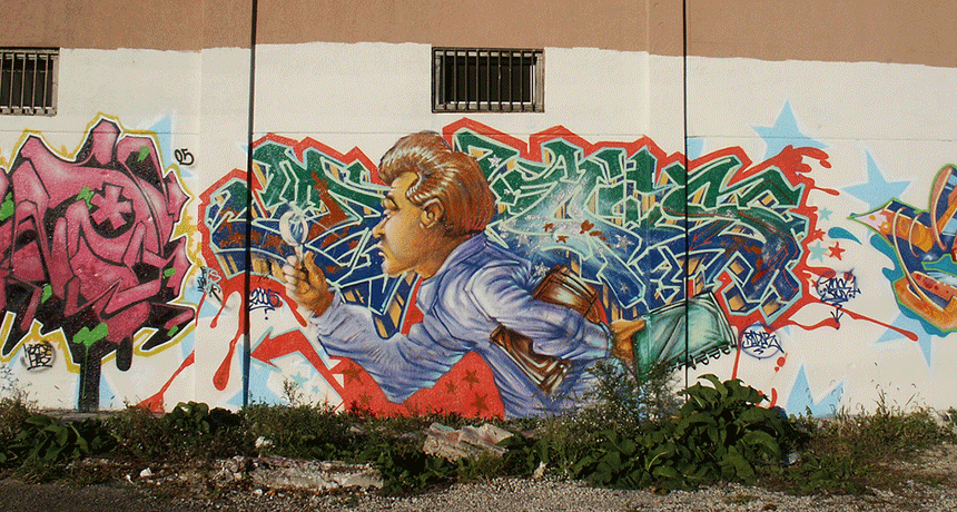
Murals like this one showcase the lively culture of Chicago’s Little Village neighborhood. But violent crime plagues some streets in the area, and sociologist Robert Vargas says changing boundaries of voting districts may contribute to this.
Señor Codo/Flickr (CC BY-SA 2.0)
AUSTIN, Texas — Fifteen-year-old Hadiya Pendleton was shot just eight days after she took part in the 2013 inauguration activities for President Barack Obama. In late April 2018, two young men are scheduled to go on trial for her murder in Chicago, Ill. Thousands more violent crimes take place in the United States each year. Many of the victims are teens.
Poverty, gang activity, the average age of residents and police resources are just a few of the things that affect where crime rates tend to be higher. Robert Vargas is a social scientist at the University of Chicago. He and his team say politicians also can affect crime rates by the way they draw the boundaries of whose homes will be in — or now out of — a voting district. Vargas talked about the work on February 17 at the annual meeting of the American Association for the Advancement of Science here in Austin.
Chicago is the third largest U.S. city. Its 2.7 million residents are spread out over an area spanning 600 square kilometers (234 square miles). As is true for many big cities, the area is divided into what are known as city blocks. Each block is determined by the streets on its edges. Often the blocks are rectangular in size. In Chicago, there are about five blocks (as measured on the long side) to a kilometer. That’s about eight per mile.
Vargas’ team focused on Chicago’s Little Village neighborhood. It has a lot of Latino and African-American residents. Many of them are poor. Most violent crime in Little Village takes place within two big clusters of city blocks and one small cluster. That’s also true for Chicago as a whole, Vargas says. From 2012 to 2014, about half of Chicago’s violent crimes took place within just five percent of its city blocks.
Over time, the violent crime rate had started to fall in Little Village’s central crime cluster. The rate stayed high in the other large cluster, at the eastern edge of Little Village. Vargas and his team wanted to know why. So they probed.
When the boundaries shift
For the last several decades, the central cluster of Little Village’s high-crime blocks all sat within one voting district. The people here were all represented by one member, or alderman, on the city’s governing council. In contrast, parts of the large eastern cluster were spread across three different voting districts, with three aldermen. What’s more, the borders of who fell into which voting district there shifted several times.
The goal is to usually have roughly equal numbers of people represented by each governing official within some region. So U.S. states may redraw the borders of voting districts from time to time as those areas gain or lose residents. Chicago is among the cities that do the same thing for the districts represented on its city council.
Politicians draw those boundaries. And the political party that is in the majority will often try to draw the lines to help keep its officials in office when people vote in the next election. That trick is called gerrymandering. This type of maneuvering took place in Chicago for several decades, Vargas says. It started in the 1980s.
In gerrymandering, politicians often divide people who would likely vote for their opponents into several districts. That can dilute the ability of those voters to unite behind one opponent and bring him or her into office.
For many, many decades, Democrats have dominated Chicago’s city elections. At first, the city’s mainstream Democrats tried to keep a coalition of other groups from winning more seats on the city council. Later, politicians likely made deals to swap city blocks in and out of districts, Vargas notes. Their talks were not public. So there are no written records of the discussions.
Along the way, the eastern cluster of Little Village’s high-crime blocks got split among three districts. This meant its residents became a very small share of each district’s voters. As a result, the aldermen who represented them would have had less of an incentive to focus on their particular interests or needs, Vargas suspects.
That could mean less money and other resources for social services went into the area, he notes. And that, he says, could have affected the crime rate. In fact, the eastern area of Little Village did have fewer programs meant to prevent violent crime, while the central area had more.
In 2016, Vargas wrote about this in a book that he called Wounded City: Violent turf wars in a Chicago barrio.
Going further
However, showing a link — or correlation — between two things doesn’t prove that one caused the other. Vargas and his team dug into the issue more deeply. This time they used more math with computers and statistics.
They started by going through old public records. They wanted to see whether the boundaries of districts had changed over time. To do this, they entered all Chicago map information into a database. They also entered in data about the people in different census tracts. The national Census Bureau uses those tracts to count and describe the entire U.S. population. The areas in its tracts tend to change little over time.
Next Vargas and his crew became matchmakers.
Using a computer program, they found groups of Chicago census tracts with violent neighborhoods. Then they identified which of those tracts had been split since 1961 between different city-council voting districts. Their computer then paired those areas with other groups of Chicago census tracts whose residents had stayed in the same voting district all of that time.
The areas in each pair had about the same racial make-up. Each pair had about the same share of residents living at or below the poverty line. But one area in each pair had been moved between different voting districts, while the other stayed put. This matching process let the team compare areas on an “apples to apples” basis, Vargas explains. All things were equal except the stability of the voting districts.
“When you compare similar neighborhoods and isolate that difference, the [murder] rate is two-and-a-half times higher in the gerrymandered area,” Vargas now reports. As he sees it, splitting areas between different voting districts slowed the flow of money and other resources that could have helped cut crime. Politicians probably never thought that their actions might have such impacts, he says.
Vargas plans to soon publish these new findings in a research journal. Going forward, he wants to see if similar effects might exist for other social factors, such as disease rates. And similar things likely happen elsewhere, he says.
David Hureau is a sociologist at the University at Albany in New York. He and other social scientists often look at units like neighborhoods or police districts. Hureau likes the idea of using voting districts as another way to probe for trends. “The approach is interesting and makes sense,” he says.


