Hurricane Harvey proved to be a tornado master
Nothing could be scarier than a twister inside of a giant windstorm

The twirling winds in hurricanes can spawn tornadoes (as in this artist’s depiction). Harvey’s winds generated a record number of warnings — and dozens of twisters.
Ig0rZh/iStockphoto
What could be worse than being hit by a hurricane? How about finding yourself in the path of a tornado — within a hurricane! It sounds crazy, but it happens — and more than you might think. Hurricane Harvey is a great example. This 2017 tropical cyclone spun up more than 30 tornadoes across the Texas Gulf Coast during late August, at the height of the tropical cyclone’s fury.
For twisters to form, winds in the atmosphere must change speed and direction with height. This is a phenomenon that meteorologists call wind shear.
When two large masses of air — each moving in different directions and at different heights — approach one another, wind shear can develop in the area between them. This can lead to horizontal eddies and tubes of turning air. That alone is not a problem. Trouble unfolds when thunderstorm updrafts — pockets of warm, rising air — bump into and tilt these horizontal tubes, stretching them vertically (up and down). If the spinning tube of air descends to the ground, it can become a tornado.
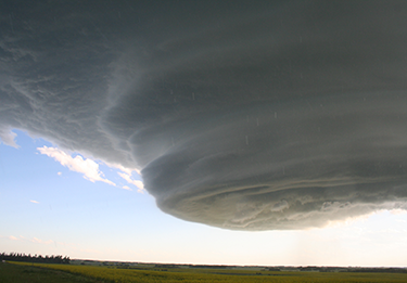
Large, rotating thunderstorms — called supercells — can form in an environment with significant wind shear. That’s why most twisters are linked to such storms.
Tropical cyclones, by contrast, tend to form in areas with little pre-existing wind shear. In fact, too much wind high up in the sky could tear apart one of these storms before it’s had a chance to organize into a full-blown hurricane. But once a hurricane (or typhoon or cyclone) does form, watch out. The chaotic winds inside it now can produce wind shear. And it is at this stage that tornadoes may develop.
That explains why some powerful hurricanes have proven prodigious sources of tornadoes. Take Harvey. People reported 33 funnel clouds touching down during this storm. That’s according to the Storm Prediction Center — also known as the U.S. government’s “tornado central.” This branch of the National Weather Service, in Norman, Okla., specializes in forecasting and research on severe thunderstorms.
Harvey’s twisters didn’t come as a total surprise. The National Weather Service office in Houston, Texas, issued 156 tornado warnings during the course of the storm. That was more tornado alerts in four days than throughout any entire year since that Houston office started tallying warning counts back in 1986.
Jared Guyer is the Storm Prediction Center’s lead forecaster. He is used to seeing outbreaks of tornadoes and other types of severe weather. Still, the high twister count linked to Harvey surprised even him.
“The challenge with hurricanes, and sometimes other tropical systems, is that they oftentimes introduce a long duration of favorable conditions for at least weak tornadoes,” says Guyer. And that proved true for Harvey. Six times in the past week, his office included Houston in the areas covered by its tornado watches, which are regions where the right conditions have developed to form a tornado.
Even though Harvey is one for the record books, Guyer notes it’s hardly the first tropical cyclone associated with multiple tornadoes. “One thing that had caught my eye before [Harvey’s] landfall were some similarities to a few other Texas … hurricanes,” he notes. For instance, “Hurricane Carla in 1961 had similar motion and strength to Harvey.” He notes that Carla also “was a fairly prolific tornado producer across Texas.”
As bad as Harvey was, some hurricanes have proven even more effective tornado-makers. In 2004, Hurricane Ivan spawned 120 tornadoes over just two and a half days. Together, those twisters led to seven deaths and $97 million in property damage. Hardest hit was the Florida Panhandle. But parts of Alabama and eastern Mississippi saw tornadoes, too. Ivan set the record for the most-ever twisters observed in a September tornado outbreak.
Nearly four decades earlier, Tropical Storm Buelah spun off more than 100 twisters. Robert Orton is the former climate scientist for the State of Texas. This Austin-based researcher, who conducted research into Buelah’s twisters, found that most had developed just before noon. And all were located in the northeast quarter of the storm.
Overall, his research showed, the vast majority of property damage due to Beulah in 1967 came from the hurricane. But he did turn up one especially alarming fact: Tornadoes were linked to more than nine in every 10 Beulah-related injuries and more than one in every three deaths.
How does a hurricane produce a tornado?
So how can a tornado form inside a hurricane? The answer might surprise you. But first, it helps to understand a few things about hurricanes.
Tropical cyclones in the Atlantic are born over warm water on the southern side of the equator. This region is known as the “Intertropical Convergence Zone.” Hurricane watchers, however, have nicknamed it Hurricane Alley.
This region has two key conditions: water as warm as a bathtub and weak winds overhead. But, wait — weak winds in the upper atmosphere? Hurricanes are notoriously windy. So why should calm conditions be needed to get them going?
It turns out that Atlantic hurricanes have rather humble beginnings. They start in a cluster of showers and thunderstorms that trek westward off the coast of Africa. Meteorologists refer to local storms, such as thunderstorms, as convection events. They distribute heat vertically over a small area. If they organize around a central area of low atmospheric pressure, this mass of air can start to spin.
The direction that the storm’s winds turn depends upon which hemisphere (northern or southern) it’s located in. If there is too much wind shear, though, the cluster of downpours and thunderstorms can rip apart the storm. That’s why winds aloft must remain calm to kick-start a hurricane.
But if conditions are right, this rotating convection center will spin faster and faster as it ingests more and more air. This lowers the air pressure in the center of the storm, further strengthening the winds.
In essence, a hurricane is like a giant car engine. It takes in heat and moisture. It then converts that energy to work. Afterward, it spits out the used “fuel.” In the case of a hurricane, the warm, moist air that goes in is the fuel. Once it has been “used,” the storm releases its exhaust: cool, dry, dense air. Scientists refer to that as the storm’s outflow. It will be visible in the streamers of high-level clouds that fan out from the storm’s center.
Now the magic can begin.
Air rushes into the storm from near the ocean surface. Meanwhile, air high above exits from the central region, or eye, of the tropical storm. This upper escaping air rushes away from the developing storm.
These two air masses — inflow below and outflow above — move in opposite directions. But they can eventually come into contact between three and eight kilometers (two and five miles) above sea level. And here is where wind shear develops.
You can think of this system as two stacked rotating masses of moist air. One is the brewing hurricane. Above it is an invisible storm of spinning “outflow.” Because they spin in opposite directions, they create friction. And this friction can eventually produce a region of strong wind shear.
Imagine looking down at a hurricane from above. Now divide the storm into quarters. A hurricane’s wind shear is strongest in the front right quarter, also known as the forward right quadrant. Here, the surface winds are moving in the same direction that the storm’s forward speed is taking it. This strengthens wind gusts on the ground. Even as friction slows the winds as a storm moves ashore, the winds in this quadrant are still stronger than those in any other part of the storm. At the same time, outflow winds are exiting the hurricane’s central core with impressive force.
Because of this, thunderstorms in the front right quadrant of the hurricane can begin to rotate. What’s driving them are huge amounts of rotational energy in the upper winds. Dozens of supercell thunderstorms may develop at once within a hurricane’s spiral rain bands. Each of these rotating thunderstorms may pose a threat of spinning off a tornado if and when that tropical cyclone moves ashore.
But wind shear isn’t enough to spawn tornadoes by the dozen. Also needed is for the base of the storm cloud to be relatively low to the ground.
The lower that base of rotating storm clouds is, the more likely a funnel cloud can snake down from the storm to become a tornado. And due to the hefty loads of moisture being pumped into a tropical cyclone, its moisture-heavy clouds tend to have very low bases.
Story continues below video.
Ashley McAlpine
Hurricane tornadoes can form a bit differently
Typically, the cloud base in a hurricane is far lower than in the thunderstorms that normally produce tornadoes. That’s why it’s easier for a hurricane to spawn so many funnel clouds at once: Any areas of rotating winds within a thunderstorm have a better chance of touching down.
The low cloud base and high moisture levels in a hurricane also make it extremely difficult to spot a twister — even after it’s touched down. The blinding rain, heavy fog and low storm clouds in a tropical cyclone can hide funnel clouds until they’re almost on top of you. People may get almost no warning of their arrival. That’s why it’s so important to heed official warnings about the risk of severe weather.
Another unique aspect of a hurricane’s tornadoes is that they don’t need sunlight and warmth to form. That’s unusual, notes Guyer. He says that most twister-spawning thunderstorms rely on daytime heating to form. They tend to die off when the sun sets. “That’s not the case with tropical systems like Harvey,” Guyer says. As such, their tornado threat can persist long after nightfall.
The good news is that most tornadoes that occur within hurricanes are weaker than those that touch down on the U.S. Great Plains. On the 0 to 5 scale used to rank a tornado’s strength (the Enhanced Fujita Scale), the majority of hurricane-related tornadoes fall into the EF-0, EF-1 and EF-2 categories. All have winds below 190 kilometers (120 miles) per hour.
Clearly, tropical storms and hurricanes pose all sorts of dangers beyond gale-force winds and rain. It’s one reason the federal government advises anyone in the path of a hurricane to give themselves some way to be notified in case a tornado warning is issued.


