Cool Jobs: Mapping the unknown
Scientists are charting the Earth, the cosmos and the distant past
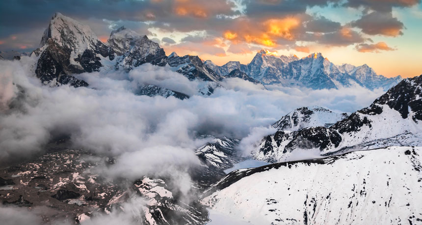
When two tectonic plates collided roughly 45 million years ago, their abutting sides began thrusting up to relieve the pressure. Its formed these Himalayan peaks. Scientists are trying to map the motions of tectonic plates going back to long before these peaks formed.
fotoksa / iStockphoto
Two hundred million years ago, Earth looked very different. Its landmass was pushed together into one giant continent. Today scientists refer to it as Pangaea. Over time, the rocky plates that make up Earth’s crust split this mega-continent apart. The plates later ripped those new continents apart, too, moving them around and smooshing some of them back together again. What resulted was the world we see on maps today.
But what did our planet look like while all of this was happening? That’s what Sabin Zahirovic is working to find out. “It’s a journey of discovery, and sometimes undiscovery, that’s exciting,” he says.
Today, GPS systems in our phones can tell us exactly where we are and how to get where we want to go. It seems like every inch of our planet has been explored. Still, some places — and times — remain unmapped.
“Earth has changed so much that it’s really a privilege to be able to look into the past. It’s the closest thing we have to time travel,” Zahirovic says.
From the ocean floor, to the mysterious force of dark energy, to the movement of continents, here are three scientists who are venturing into uncharted territory.
Putting tectonic plates on rewind
It’s hard to imagine something that moves slower than our continents. They steadily creep along at around 5 centimeters (2 inches) a year. At least, that’s what geoscientists had thought.
But when scientists at the University of Sydney in Australia studied how Earth’s crust had changed over the past 200 million years, they got a surprise. Slabs that make up Earth’s outer layer did spend most of their time crawling along at that slow pace. But every once in a while, these tectonic plates sped up in short bursts. Sometimes they sprinted at up to 18 centimeters (7 inches) a year. And they might keep up that pace for 10 million years or so.
SLIP ‘N SLIDE An animation from the EarthByte Group shows the speed at which tectonic plates have moved over time. EarthByte Group |
Scientists had long known that Earth’s tectonic plates are constantly on the move. Their activity constantly reshapes the planet’s surface. Using clues in rock, scientists reconstructed what the continents must have looked like at various times in the past. But these were only brief snapshots from every 20 million years or so. What they wanted were details of how the plates moved over much shorter timescales.
Zahirovic belongs to the EarthByte Group in Australia. Its scientists input large troves of geological data into a computer, and then use them to model how the Earth works. The goal of this computer model has been to simulate real-world events, such as the movement of tectonic plates and the continents they carried.
Zahirovic and the other scientists started by combining data from many different sources. They used data from rocks and fossils. They added satellite observations of gravity, magnetism and the shape of surface features — Earth’s topography (Tuh-PAAHG-ruh-fee). But mapping the changing boundaries of tectonic plates was trickier. Why? Many rest at the bottom of the sea.
Studying magnetic stripes
To get that type of information, the team used data on magnetic anomalies that research ships had gathered from the ocean’s floor. Scientists knew that Earth’s magnetic poles (points near the axis around which the planet rotates, and where magnetic fields point downward) switch sides. It doesn’t happen often. Just every few million years or so. But when this happens, tiny magnetic particles in the rocks near areas where the seafloor is spreading will change direction to line up with the new pole. (It’s like when iron filings are drawn toward a magnet.)
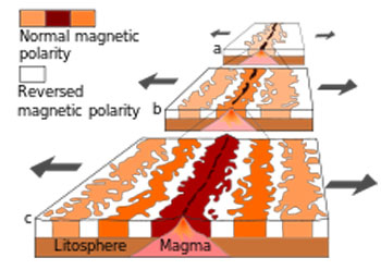
This flip flop in the magnetic poles forms magnetic “stripes” on the ocean’s floor. Those stripes provide clues to the past, similar to tree rings. Scientists can use the stripes to figure out how fast Earth’s crust pulled apart. Where this happened quickly, the lines are far apart. Where it happened slowly, they are closer together.
“Over time, you build up this magnetic [recording] of what the plates have done,” Zahirovic says. His job is to write computer programs to analyze the data. When the scientists combined all of their data, they were able to create a model that showed how the plates had moved, one million years at a time. In a sense, Zahirovic says, “We can ‘rewind’ back to when Pangaea formed — and before and after.”
His team shared its model with scientists. They made it available for free to anyone who wanted it. That should aid scientists who are curious about what Earth looked like millions of years ago. Their model also might help scientists understand other, more current issues — such as climate change.
The movement of tectonic plates is an important factor in climate change. In the past, volcanic eruptions caused by changes at plate boundaries have warmed the atmosphere by pumping out greenhouse gases. And when continents cover the north and south poles, inland ice sheets form, lowering sea levels.
“By understanding the past, you can help understand the present,” Zahirovic explains. “And also the future.”
Supernovas help probe ‘dark’ energy
Gravity is supposed to hold things together. That’s why scientists long believed one of Albert Einstein’s now debunked theories. It said that the combined gravity of all stars, planets and galaxies in the universe should act like brakes to slow the expansion of the universe. So it came as a surprise when astronomers discovered in 1998 that the universe is expanding faster and faster, not ever more slowly.
Scientists called the strange force pushing things apart “dark energy.” They didn’t know what it was. But they found it made up about 70 percent of all the matter and energy in the universe.
“Dark energy is a mysterious something that seems to be making our universe expand at an accelerated rate,” says Rachel C. Wolf. She’s a cosmologist, someone who studies the origins of the universe, at the University of Pennsylvania in Philadelphia. Wolf is one of around 320 scientists around the world working on a project known as the
.
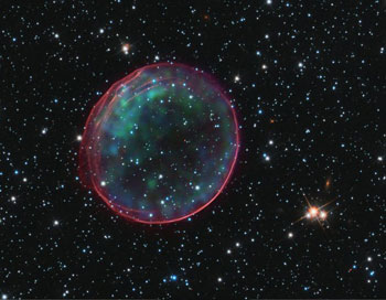
It uses a powerful telescope in Chile to study large patches of the sky. Over five years, researchers will use this telescope to survey more than 300 million distant galaxies and detect thousands of new supernovas — exploding stars. Wolf got involved in the project because she studies supernovas. They are a tool for “probing” dark energy. “I use exploding stars to learn about how our universe has evolved over time,” she explains.
When a star explodes into a supernova, it emits a flash of light that can appear brighter than a galaxy. Then it fades away over weeks to months. Different supernovas behave in different ways. But the ones Wolf studies, type 1a supernovas, are very consistent. Scientists discovered that how brightly they explode is related to how long it takes their light to fade away. This information makes type 1a supernovas useful markers for measuring distances across the universe. In a sense, their light becomes a type of cosmic “yardstick.”
By comparing the brightness of different supernovas, scientists can figure out how far they are from each other. That’s because they know how fast light travels (it’s always the same speed). Scientists
also
can analyze light from the exploding stars to learn how space was expanding at the time the supernova occurred. The faster the supernova was moving away, the more its light waves were “stretched” as they traveled toward Earth. These data can tell scientists whether the universe is expanding faster or more slowly than expected.
Although Wolf studies the sky, most of her job is spent not in front of a telescope but at a computer. She takes data from hundreds of supernovas and writes computer programs that pull out useful information. She might be asked to write a computer code that will use data about a supernova to determine how far away it is. Other programs might look for patterns in the data.
“A lot of what I do is like taking a big puzzle and trying to find the links between these different pieces,” she explains.
So far, she has tested her programs using hundreds of observations. “By the end of the survey, we’re going to have thousands of different supernovae we can look at, to learn more about dark energy,” she says.
Satellites eye the seafloor
Humans have studied nearly every inch of the seven continents. But more than 70 percent of our planet still remains largely unexplored. That’s because it’s at the bottom of the sea. Only about 11 percent of the ocean floor has been mapped in detail. Completing those maps in the past has involved sounding. This method uses sonar to bounce sound pulses off the seafloor. But a research ship would have to spend the next 200 years sailing the world’s oceans to map the entire seafloor this way.
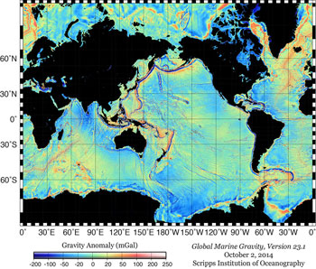
Scientists have figured out a faster way to do this — and without getting wet. They use satellites to precisely measure the topography of the ocean’s surface.
The ocean may look flat, but it is actually covered with bumps and dips. That’s because the gravitational attraction from a massive undersea mountain range causes water to pile up in a broad sea-surface bump several feet high. A deep valley leaves a slight dip in the ocean surface.
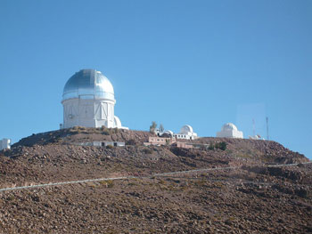
“The highs and lows [on the satellite maps] represent highs and lows on the ocean floor,” says David Sandwell. A geophysicist, he works at the Scripps Institution of Oceanography in San Diego, Calif.
By creating specialized maps of the ocean’s surface, known as marine gravity maps, Sandwell and his co-workers have discovered undersea mountain ranges and chasms (KAZ-ums). They’ve also turned up “lots and lots of seamounts” (extinct undersea volcanoes). They used this information to maps the ocean floor in detail. “Every day you see something new,” he says. “That’s the exciting part.”
“Big, long cracks” at the bottom of the sea in the South Pacific were among his team’s more surprising and mysterious discoveries. They run along seamount ridges. “We still don’t know how they form, and we don’t know how old they are,” Sandwell says. “We can see them, but we still don’t understand them.”
Radar to the rescue
To create their maps, he and his colleagues use data from satellites equipped with altimeters. These instruments shoot a radar beam at the surface of the ocean and measure the time it takes to bounce back. That measurement tells scientists the distance a beam traveled — and the precise height of the ocean at that location. Those height measurements are accurate to within “a centimeter [0.39 inch],” Sandwell says.
The altimeter shoots around 2,000 radar signals each second to collect many measurements. When the scientists find something that looks interesting, they might plan an expedition to study the area by ship. By taking soundings from a ship and making other measurements, they are able to get a much more detailed picture of what’s below. “You run the ship back and forth, just like mowing the lawn, building up a complete map of the sea floor,” Sandwell says.
So ship soundings can offer more detail of features first spied by satellite, he notes.

We’ll never have to hike or drive across the seafloor, so why do we need maps of it? Aside from human curiosity, military agencies use the information for navigation. And much of the money for research comes from energy companies, which search for places to drill for oil at shallow sites on the seafloor.
But for scientists, learning about the ocean’s floor can give a new understanding of Earth and how it works. The planet’s surface is constantly being recycled as tectonic plates slide underneath one another. It’s a process called subduction. As a result, the ocean’s floor is much younger geologically than will be the continental landmasses. It’s also not affected by some of the forces that have shaped the land above sea level, such as erosion. That intrigues scientists like Sandwell. “It’s like a different planet down there,” he says.
Humans can never visit long-gone Pangaea nor the distant edges of the universe. Most will never travel to the ocean’s depths. So scientists have found different ways to explore these places: using satellites, telescopes and clues from Earth itself. By mapping the unknown, they are helping answer many questions about our mysterious world.
This is one in a series on careers in science, technology, engineering and mathematics made possible with generous support from Alcoa Foundation.
Power Words
(for more about Power Words, click here)
acceleration A change in the speed or direction of some object.
altimeter An instrument used to determine altitude, or height above a surface.
anomaly A brief and unexpected difference; something that is unusual and especially outside the normal range of what occurs.
astronomy The area of science that deals with celestial objects, space and the physical universe. People who work in this field are called astronomers.
atmosphere The envelope of gases surrounding Earth or another planet.
axis The line about which something rotates. On a wheel, the axis would go straight through the center and stick out on either side. (in mathematics) An axis is a line to the side or bottom of a graph; it is labeled to explain the graph’s meaning and the units of measurement.
chasm A great or deep gulf or fissure in the ground, such as a crevasse, gorge or breach. Or anything (or any event or situation) that would seem to present a struggle in your attempt to cross to the other side.
climate change Long-term, significant change in the climate of Earth. It can happen naturally or in response to human activities, including the burning of fossil fuels and clearing of forests.
computer model A program that runs on a computer that creates a model, or simulation, of a real-world feature, phenomenon or event.
continent (in geology) The huge land masses that sit upon tectonic plates. In modern times, there are six geologic continents: North America, South America, Eurasia, Africa, Australia and Antarctica.
cosmic An adjective that refers to the cosmos — the universe and everything within it.
cosmology The science of the origin and development of the cosmos, or universe.
cosmos (adj. cosmic) A term that refers to the universe and everything within it.
dark energy A theoretical force that counteracts gravity and causes the universe to expand at an accelerating rate.
debunk Use data and logic to refute some idea, theory or argument.
Earth’s crust The outermost layer of Earth. It is relatively cold and brittle.
erosion The process that removes rock and soil from one spot on Earth’s surface and then deposits the material elsewhere. Erosion can be exceptionally fast or exceedingly slow. Causes of erosion include wind, water (including rainfall and floods), the scouring action of glaciers, and the repeated cycles of freezing and thawing that often occur in some areas of the world.
fossil Any preserved remains or traces of ancient life. There are many different types of fossils: The bones and other body parts of dinosaurs are called “body fossils.” Things like footprints are called “trace fossils.” Even specimens of dinosaur poop are fossils. The process of forming fossils is called fossilization.
galaxy A massive group of stars bound together by gravity. Galaxies, which each typically include between 10 million and 100 trillion stars, also include clouds of gas, dust and the remnants of exploded stars.
geology The study of Earth’s physical structure and substance, its history and the processes that act on it. People who work in this field are known as geologists. Planetary geology is the science of studying the same things about other planets.
geophysics The study of matter and energy on Earth and how they interact. Scientists who work in this field are known as geophysicists.
geoscience Any of a number of sciences, like geology or atmospheric science, concerned with better understanding the planet.
global positioning system Best known by its acronym GPS, this system uses a device to calculate the position of individuals or things (in terms of latitude, longitude and elevation — or altitude) from any place on the ground or in the air. The device does this by comparing how long it takes signals from different satellites to reach it.
gravity The force that attracts anything with mass, or bulk, toward any other thing with mass. The more mass that something has, the greater its gravity.
greenhouse gas A gas that contributes to the greenhouse effect by absorbing heat. Carbon dioxide is one example of a greenhouse gas.
ice sheet A broad blanket of ice, often kilometers deep. Ice sheets currently cover most of Antarctica. An ice sheet also blankets most of Greenland. During the last glaciation, ice sheets also covered much of North America and Europe.
intrigue (v.) To fascinate or arouse curiosity about something.
landmass A continent, large island or other continuous body of land.
magnet A material that usually contains iron and whose atoms are arranged so they attract certain metals.
magnetic pole The point near Earth’s axis of rotation, where magnetic fields point downward.
matter Something which occupies space and has mass. Anything with matter will weigh something on Earth.
model A simulation of a real-world event (usually using a computer) that has been developed to predict one or more likely outcomes.
open-source software Software that is shared for free with the public.
Pangaea (or Pangea) The supercontinent that existed from about 300 to 200 million years ago and was composed of all of the major continents seen today, squished together.
planet A celestial object that orbits a star, is big enough for gravity to have squashed it into a roundish ball and it must have cleared other objects out of the way in its orbital neighborhood. To accomplish the third feat, it must be big enough to pull neighboring objects into the planet itself or to sling-shot them around the planet and off into outer space. Astronomers of the International Astronomical Union (IAU) created this three-part scientific definition of a planet in August 2006 to determine Pluto’s status. Based on that definition, IAU ruled that Pluto did not qualify. The solar system now includes eight planets: Mercury, Venus, Earth, Mars, Jupiter, Saturn, Uranus and Neptune.
plate boundary (in geology) The edge of a tectonic plate, or the place where two or more tectonic plates meet.
radar A system for calculating the position, distance or other important characteristic of a distant object. It works by sending out periodic radio waves that bounce off of the object and then measuring how long it takes that bounced signal to return. Radar can detect moving objects, like airplanes. It also can be used to map the shape of land — even land covered by ice.
satellite A moon orbiting a planet or a vehicle or other manufactured object that orbits some celestial body in space.
sea level The overall level of the ocean over the entire globe when all tides and other short-term changes are averaged out.
seamount A mountain (usually formed by a volcano) whose entire structure sits below the surface of the ocean. If it broke the surface, it would become an island.
sonar A system for the detection of objects and for measuring the depth of water. It works by emitting sound pulses and measuring how long it takes the echoes to return.
star Thebasic building block from which galaxies are made. Stars develop when gravity compacts clouds of gas. When they become dense enough to sustain nuclear-fusion reactions, stars will emit light and sometimes other forms of electromagnetic radiation. The sun is our closest star.
subduct or subduction The process by which tectonic plates sink or slide back from Earth’s outer layer into its middle layer, called the mantle.
supernova (plural: supernovas or supernovae) A massive star that suddenly increases greatly in brightness because of a catastrophic explosion that ejects most of its mass.
tectonic plates The gigantic slabs — some spanning thousands of kilometers (or miles) across — that make up Earth’s outer layer.
telescope Usually a light-collecting instrument that makes distant objects appear nearer through the use of lenses or a combination of curved mirrors and lenses. Some, however, collect radio emissions (energy from a different portion of the electromagnetic spectrum) through a network of antennas.
theory (in science) A description of some aspect of the natural world based on extensive observations, tests and reason. A theory can also be a way of organizing a broad body of knowledge that applies in a broad range of circumstances to explain what will happen. Unlike the common definition of theory, a theory in science is not just a hunch. Ideas or conclusions that are based on a theory — and not yet on firm data or observations — are referred to as theoretical. Scientists who use mathematics and/or existing data to project what might happen in new situations are known as theorists.
topographical map A map that shows details of bumps and valleys in a planet’s landscape. A topographical map shows relief features, meaning that it conveys information about elevation changes from one spot on the map to another.
topography The height, shape and arrangement of physical features on the Earth or another surface.
type 1a supernova A supernova that results from some binary (paired) star systems in which a white dwarf star gains matter from a companion. The white dwarf eventually gains so much mass that it explodes.
universe The entire cosmos: All things that exist throughout space and time. It has been expanding since its formation during an event known as the Big Bang, some 13.8 billion years ago (give or take a few hundred million years).
volcano A place on Earth’s crust that opens, allowing magma and gases to spew out from underground reservoirs of molten material. The magma rises through a system of pipes or channels, sometimes spending time in chambers where it bubbles with gas and undergoes chemical transformations. This plumbing system can become more complex over time. This can result in a change, over time, to the chemical composition of the lava as well. The surface around a volcano’s opening can grow into a mound or cone shape as successive eruptions send more lava onto the surface, where it cools into hard rock.
Word Find (click here to enlarge for printing)


