How the Arctic Ocean became salty
A land bridge had to sink far enough below a top-of-the-world lake to let Atlantic saltwater overwhelm it
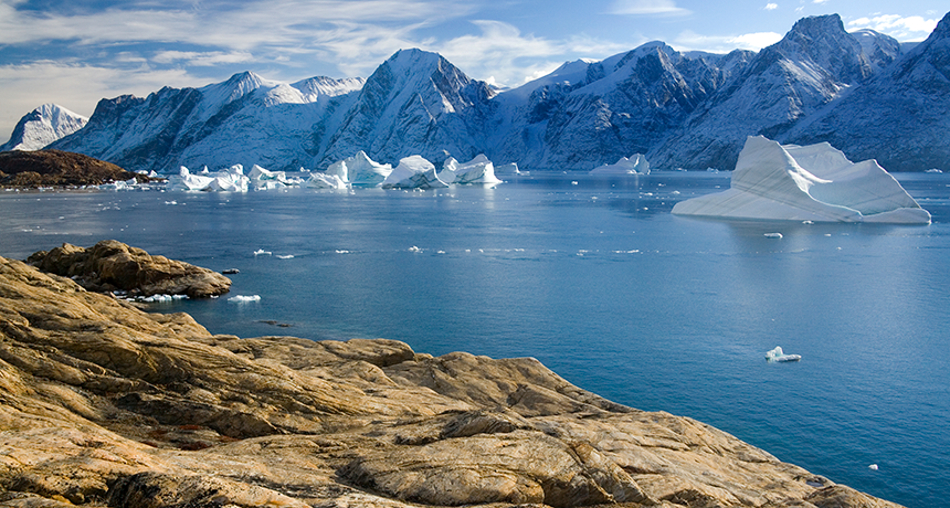
The Arctic Ocean didn’t become salty until a stretch of land that ran from Greenland (pictured here) to Scotland sank far enough beneath the sea, a new study finds.
SteveAllenPhoto/iStockphoto
Tens of millions of years ago, the Arctic Ocean was a huge freshwater lake. A land bridge separated it from the salty Atlantic Ocean. Then, around 35 million years ago, that bridge began sinking. Eventually, it fell enough that the Atlantic’s salty seawater could seep into the lake. But it hadn’t been clear precisely how and when that top-of-the-world lake became an ocean. Until now.

A new analysis describes the conditions that allowed the Atlantic’s water to overwhelm that Arctic lake, creating the world’s northernmost ocean. Its cold, south-flowing water now exchanges with warmer, north-flowing water from the Atlantic. Today, that’s what powers the Atlantic Ocean’s climate-driving currents.
Things were much different 60 million years ago. Back then, a strip of land stretched between Greenland and Scotland. This Greenland-Scotland Ridge formed a barrier that kept the salty water of the Atlantic out of the fresher water of the Arctic, explains Gregor Knorr. Knorr is a climate scientist at the Alfred Wegener Institute in Bremerhaven, Germany. He worked on the new study, published June 5 in Nature Communications.
At some point, the ridge sank far enough to let the two bodies of water mix. To find out when that was, Knorr and his Alfred Wegener colleagues ran computer models. Like time machines, these computer programs recreate or predict complex scenarios based on various conditions. Models can compress changes that took millions of years into just weeks. Earth scientists then compare them like time-lapse camera images.
To make the models as accurate as possible, Knorr’s team plugged in several factors. These included a range of carbon dioxide (CO2) levels typical of what would have been in the atmosphere at important times in the past. Those CO2 values ranged from 278 parts per million (ppm) — similar to values to just before the Industrial Revolution (when humans started adding lots of CO2 to the air) — to 840 ppm. That high is what would have existed in parts of the Eocene Epoch, 56 million to 33 million years ago.
The link between CO2 and salinity is a powerful one, explains Knorr. The more CO2 in the atmosphere, the warmer the climate. The warmer the climate, the more ice melts. And the more ice melts, the more freshwater pours into the Arctic Ocean. That, in turn, lowers its saltiness.
The team set out to simulate the period of time from 35 million years ago to 16 million years ago. First, they divided that time period into increments of 2,000 to 4,000 years. Then they let their model recreate all of those smaller time periods at once, Knorr says. They couldn’t do that with the whole 19-million-year period because it took a supercomputer running continuously for as long as four months just to run the smaller models.
Just add salt
The result that emerged from these models was crystal clear. Around 35 million years ago, Arctic water was still as fresh as a spring pond. That was true even though the ridge was already 30 meters (98 feet) underwater.
Story continues below image.
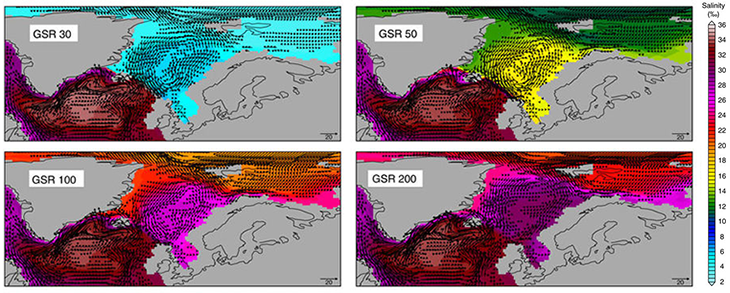
But within the next million years or so, the ridge sunk to 50 meters (164 feet) below the surface. That’s when things really started to change. And here’s why. Freshwater is less dense than salt water. So it will floats on any denser, saltier water below it. The line between this layer of fresh and salty water is known as a halocline.
With all the freshwater being added to the Arctic from melting ice around 35 million years ago, the halocline was especially abrupt. And it happened to be some 50 meters (about 160 feet) deep.
So the salt water didn’t pour north until the Greenland-Scotland Ridge sank below that halocline. Only when that happened could the dense salt water of the Atlantic Ocean finally sweep into the Arctic.
That “simple effect” — warmer salt water pouring north and cold fresh water spreading south — forever changed the Arctic and Atlantic oceans. Along with adding salt water and heat to the Arctic, it also helped trigger the major Atlantic Ocean currents that exist today. Those currents arise from differences in water density and temperature.
Chiara Borelli is a geologist at the University of Rochester in New York. Borelli was not involved in the new study. She has, however, investigated Earth’s climate and oceans during the timeframe modeled here. Concludes Borelli, the study fits well into the long-term debate on how the Greenland-Scotland Ridge impacted oceans and climate. She says, “This adds a piece of the puzzle to how the connection started.”


