Watching our seas rise
Satellites, coral reefs, ancient Roman fishponds and sinking cities help us understand how humans are changing sea level
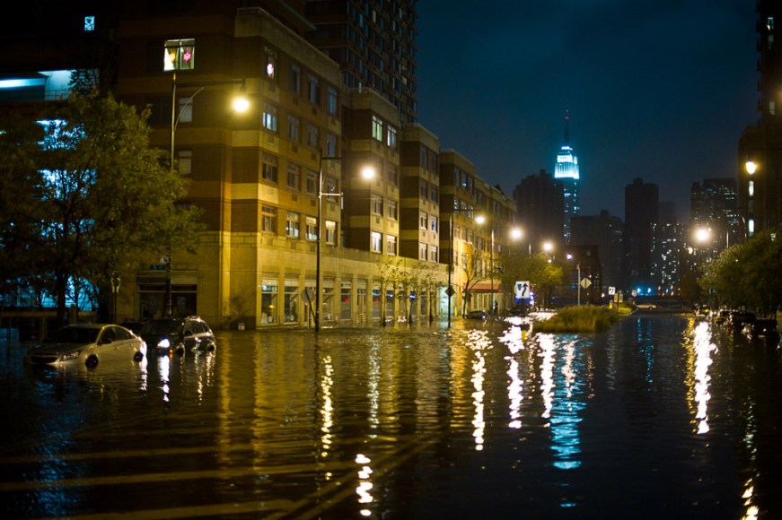
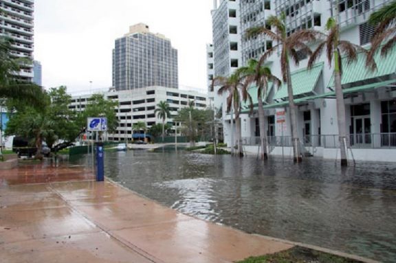
Storm surges as high as 3.3 meters (11 feet) swept over New Jersey and New York coastlines when Superstorm Sandy came ashore October 29. This photo shows flooding in Long Island City. Across the East River, in New York City, rising waters flooded streets, homes and subway tunnels.
Sascha Reinking Photography
Visit the beach on a hot afternoon and you may not realize it, but someone — or rather something — is watching from above. If you stand in the right place, the silent watcher’s invisible spotlight will pass right over you, like the spotlight of a police helicopter flitting overhead.
That aerial observer zooming over your head is the Jason-2 satellite. It flies 1,340 kilometers (832 miles) high — as far above the ground as New York City is from Chicago. It travels 25,000 kilometers per hour, 27 times as fast as a commercial jet. And it circles Earth a little over 12 times a day.
Two thousand times per second, Jason-2’s spotlight — pointed down at Earth — flashes on for an instant. It isn’t a flash that you could see even if you were looking. The spotlight is throwing off radio waves, which are invisible to the eyes of humans and other animals. Those waves ripple down to Earth and bounce off of its surface, back into space. A computer aboard the satellite times exactly how long those reflected radio waves take to return — usually, about nine-thousandths of a second.
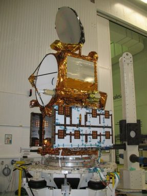
By measuring how long the signal takes to bounce back, Jason-2 can measure the distance between itself and Earth’s surface. The satellite was launched into space to measure sea-surface heights. Or, more to the point, Jason-2 is measuring how quickly the planet’s seas are rising.
Scientists these days are worried about sea level. As Earth warms, the surface of the ocean is creeping upward. This creep is happening partly because saltwater expands a tiny bit as it warms. “Warmer water literally is taller,” explains Josh Willis. He’s a climate scientist at the NASA Jet Propulsion Laboratory in Pasadena, Calif.
Sea level also is rising because warm temperatures have prompted glaciers in Antarctica, Greenland and other usually cold places to melt more quickly. Glaciers are essentially rivers of ice, and their melting adds freshwater to the ocean. Antarctica and Greenland are together losing about 350 cubic kilometers of ice per year — enough meltwater to fill up 80,000 Yankee baseball stadiums. Spread over the world’s oceans, that meltwater alone raises sea level about 1 millimeter (1/25th of an inch) or so each year.
Jason-2 has shown that overall, sea level is currently rising about 2.4 millimeters per year — a little more than the thickness of a quarter.
That may not sound like much — but those quarters stack up year after year. This slow rise is expected to cause flooding in many of the world’s coastal cities in the next 50 to 100 years. Worse yet, the speed of sea level rise is also expected to grow. Seas may eventually rise four to eight times faster than they are today.
High and dry
Scientists have long known that sea level changes over time. Paul Hearty, a geologist at the University of North Carolina at Wilmington, has found boulders covered in barnacle shells some 30 meters (100 feet) above sea level. Those high and dry barnacles are several million years old. They serve as evidence that sea level was once much higher. Scientists have also found dead coral reefs buried 150 meters beneath the sea. When that coral was alive, it grew just below the water’s surface. Today, those coral skeletons provide evidence that sea level was once much lower, too.
Sea level has risen and fallen in sync with the ice ages, over hundreds of thousands of years. During past ice ages, oceans were lower because more water was tied up in glaciers on land. But between ice ages, sea level sometimes rose higher than it is today, as melting glaciers sweated their water into the ocean. Some 125,000 years ago, just before the last ice age began, sea level was a whopping 5 to 8 meters (16 to 26 feet) higher than it is today.
The big challenge for scientists has been how to measure changes to sea level throughout the past 50 to 100 years. Bruce Douglas, a retired scientist who worked for 20 years at the National Oceanic and Atmospheric Administration, or NOAA, in Rockville, Md., spent years working on this. During the 1980s and 1990s he measured sea level rise by studying records from tide gauges. Harbor operators have relied on these devices for more than 200 years to monitor the water level in coastal areas in order to alert ships at risk of running aground. But the gauges gave a limited picture: They measured the level of the world’s oceans, which cover 360 million square kilometers (139 million square miles), in only 20 or 30 places!
The bumpy ocean
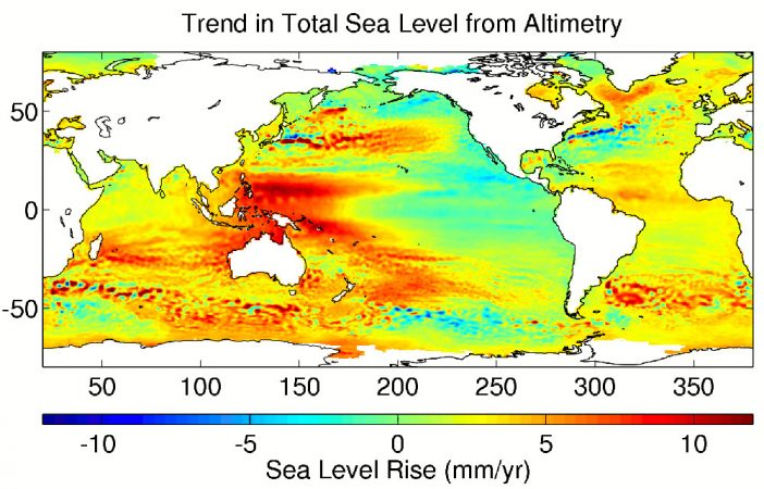
Scientists have gradually solved that problem as satellites have become accurate enough to monitor sea level. Several satellites, including Jason-2, have now been shot into orbit for this purpose. These satellites let scientists do something that they could never do before: measure sea level not just in a few places along the coast, but also across the entire length and breadth of the world’s oceans.
These fuller measurements revealed something amazing: Unlike the water in your bathtub, the sea is actually bumpy!
Sea level varies from one part of the ocean to another by a meter or more. And how quickly sea level is rising also varies from place to place. For example, sea level in the western Pacific Ocean, near the island nations of Indonesia and the Philippines, is rising three times faster than the global average.
The ocean’s warming causes much of this bumpiness. During so-called El Niño years, when waters of the eastern Pacific Ocean warm to about 1°C (1.8 °F) higher than usual, the sea level off of California’s coast can rise by 10 or 20 centimeters (4 to 8 inches). This is caused by the expansion of the warming seawater. But the world’s oceans aren’t warmer overall during an El Niño period. Heat has just shifted from one place to another: As the eastern Pacific warms, the western Pacific cools down, causing sea level there to temporarily drop.
So sea level operates a bit like a water bed: Push down on it in one place and it will rise in another. By averaging out all of those bumps detected by Jason-2 and other satellites, scientists have calculated that the world’s oceans are rising by about 2.4 millimeters per year.
The big question for scientists like NASA’s Willis is: Has sea level been rising that fast for millennia? Or did this rate of sea level rise begin much more recently? In the past century or two, humans began spewing more carbon dioxide into the air through the burning of fossil fuels such as coal, oil and natural gas. And as a type of greenhouse gas, carbon dioxide helps warm Earth’s atmosphere — and its seas. So it would make sense that the seas started rising more quickly in the last few hundred years.
Roman fishponds
Archeologists studying ancient fishponds built by the Romans 2,000 years ago have now helped to answer this important question.
The Romans built dozens of saltwater ponds in southern Europe, along the edge of the Mediterranean Sea. Their goal was to farm fish for dinner. Channels connected the sea to the ponds, which were replenished during high tides. So the ponds had to be built right at sea level. But today, you have to go snorkeling to see the stone walls that the Romans built to contain their ponds: They sit 1 meter under water. They were submerged by rising seas.
Those ponds show that sea level has risen by no more than 1 meter in the last 2,000 years — less than one-tenth of a millimeter per year. If sea level is currently rising 2.4 millimeters per year, then it is rising at least 20 times as fast as it has, on average, since the fishponds were built!
Concludes Willis, “The last 150 years have seen much more rapid rise than at any other time in the last 2,000 years.”
That escalation started just as humans began producing large amounts of carbon dioxide.
And scientists expect sea level rise to speed up even more. As ice melts around the edges of Antarctica and Greenland, some glaciers there have sped up to two, four, and in some cases, even eight times their former speed. As a result, they are dumping ice into the ocean much more quickly than before. Each year, both Greenland and Antarctica are losing a little more ice than the year before. So if sea level rise is speeding up, how fast could it get?
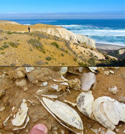
Drowned coral reefs
History provides some worrisome hints. These warnings come from dead coral reefs that scientists have found in deep water off the coasts of Hawaii, Tahiti and Australia. Because corals depend on sunlight that filters through the water, they can survive only a few meters deep. The dead reefs “drowned” in darkness when the sea level jumped, suddenly putting them too far underwater to survive.
“There were huge changes in sea level from 20,000 years ago to about 10,000 years ago” as ice sheets in Antarctica, Greenland, North America and Europe were melting, says Douglas, the retired NOAA scientist. The biggest of those changes, a disaster that scientists call Meltwater Pulse 1A, drowned those coral reefs. Meltwater Pulse 1A was an episode of runaway melting that lasted for 200 to 500 years. During that time, sea level rose by at least 4 meters per century — 16 times faster than today.
Sea level rise probably won’t skyrocket that quickly in the near future. There simply isn’t as much ice in the world to melt all at once as there was 14,000 years ago. But sea level rise could still speed up quite a bit.
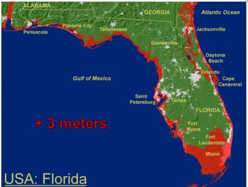
Two separate research teams, including one led by Martin Vermeer at Helsinki University of Technology in Finland, predict that sea level will still rise anywhere from 0.75 meters to 1.9 meters by the year 2100. The top end of that range is taller than most grownups (a 6 foot man is only 1.8 meters tall). In order for sea level to reach these heights so soon, it would need to be rising 15 to 30 millimeters per year by the year 2100 — 6 to 12 times faster than it is today.
The year 2100 may seem pretty far off. But if you’re a teen today, then there’s a very good chance that you’ll live to see it. And that kind of sea level rise will cause some huge problems.
Storm surges
A rise in sea level of just 1 meter would directly affect 3.7 million people in the United States alone. That’s according to predictions by Jeremy Weiss and Jonathan Overpeck. These climate scientists work at the University of Arizona in Tucson. Earlier this year, they published a study indicating that such a rise would put the homes of those millions of people in contact with seawater during ordinary high tides that happen every month.
Some towns already sit on the edge. Every now and then in downtown Miami, unusually high tides cause the streets to flood as ocean water pushes through the storm sewers and gurgles up from the manholes like a sea monster. These tides are caused by minor changes in the wind, or by storms passing by hundreds of miles away. “We are getting sea levels 1.5 to 2 feet [45 to 60 centimeters] above the normal projected level almost every year now,” says Harold Wanless, a geologist at the University of Miami. “It’s just starting to show how vulnerable we are.”
But the worst effects will happen during large storms called hurricanes that form over the ocean. As a hurricane comes ashore, its howling winds push a pile of seawater forward. These water piles, called storm surges, can tower as much as 8 meters (26 feet) above normal sea level. Two-meter (6.5-foot) storm surges are common for weaker hurricanes. Storm surges can spill into coastal towns, washing away buildings and cars. (In one part of New York City, the storm surge associated with Superstorm Sandy on October 30 broke a record. The coastal water briefly rose by 13.88 feet — more than 2 feet higher than the previous record, set 191 years earlier. Flowing over seawalls, this surge flooded parts of lower Manhattan.)
Sea level rise could cause future storm surges to start out a meter higher, says Robert Deyle, an environmental planning professor at Florida State University in Tallahassee. “Storms are going to flood further inland,” he concludes.
In the United States, regions from Texas to North Carolina would suffer the most from hurricanes. Preventing flooding there will require that hundreds of kilometers of seawalls and dikes be built. In some places, though, sea level rise will be made even worse by other environmental problems that humans have caused.
Sinking land
Some 2.2 million people live just north of the city of Manila in the Philippines. This area is known as KAMANAVA (an abbreviation combining the names of four towns). Already, high tides flood some streets in KAMANAVA several times each year — and these floods can last weeks.
The sea around the Philippines is rising 7 to 8 millimeters per year, three times the worldwide average. But this is only part of the problem. Even as the sea around Manila and KAMANAVA rises, the land they sit on is sinking. This sinking is called subsidence.
The land is sinking because people have drilled so many wells and pumped so much water out of the ground for drinking and for watering crops. They have pumped out 7 cubic kilometers of water — almost enough water to build a mountain the size of Pikes Peak in Colorado! The depleted land is deflating, like an apple shrinking as it dries. It is sinking 90 millimeters (3.5 inches) per year in some spots.
“In those places we have a lot of road-raising projects,” explains Fernando Siringan. He’s a coastal geologist at the University of the Philippines in Diliman. To keep those roads above water, the government has to raise roads by almost a meter — “and then do it again after two or three years,” he notes. “It’s not cheap.”
Humans have caused coastal land to sink in many other places, too — including China, the Netherlands, southeast England and parts of the United States. Some areas of New Orleans have sunk 5 meters (16 feet) in the last 150 years. And that partly explains why the city was devastated in 2005 by storm surges from Hurricane Katrina.
Many people have referred to sea level rise as a future problem. But KAMANAVA and New Orleans offer two examples of how in some parts of the world sea level rise is already a problem. A problem that scientists need to watch closely.
The Jason-2 satellite that is tracking sea level will have to be replaced in several years. Heavy radiation from the sun is slowly cooking the satellite’s computers. And in order to make exact measurements of the sea’s height, Jason-2 has to travel a precise orbit around Earth. But as it zooms around Earth 4,562 times each year, this satellite is slowly wandering out of that orbital path.
Willis, the NASA scientist, is part of the team that is getting Jason-2’s replacement ready. “Jason-3 is almost a carbon copy of Jason-2,” he says. When Jason-3 blasts into space in 2014, Willis will be one of the people eagerly watching the information that it beams back to Earth.
Word Find (click here to enlarge puzzle for printing)


