Explainer: What is an atmospheric river?
These long-traveling storm systems have the potential to bring floods and mega snowfalls
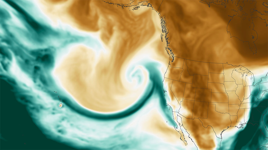
A dense atmospheric river of water vapor (dark blue-green) swirls around drier air (brown) as it streams toward the west coast of the U.S. on January 4, 2023. This storm brought high winds and extensive flooding. Bluer colors indicate more water vapor per area in the atmosphere.
LAUREN DAUPHIN/NASA EARTH OBSERVATORY
“Atmospheric river” may sound airy and delicate. In fact, the term describes massive, fast-moving storms that can hit as hard as a freight train. Some unleash huge, flooding downpours. Others can quickly bury towns under a meter or two (up to six feet) of snow.
These long, narrow bands of condensed water vapor form over warm ocean waters, often in the tropics. They can often reach 1,500 kilometers (930 miles) long and be one-third that wide. They’ll snake through the sky like giant rivers, transporting huge amounts of water.
On average, one atmospheric river can transport up to 15 times the volume of water leaving the mouth of the Mississippi River. When these storms arrive over land, they can drop much of their moisture as drenching rains or mega snowfalls.
Marty Ralph at the University of California, San Diego, knows a lot about these rivers in the sky. He works as a meteorologist at the Scripps Institution of Oceanography. Atmospheric rivers can bring welcome water to a parched region. However, Ralph adds, they also are “the primary, almost the exclusive” cause of floods on the U.S. West Coast.
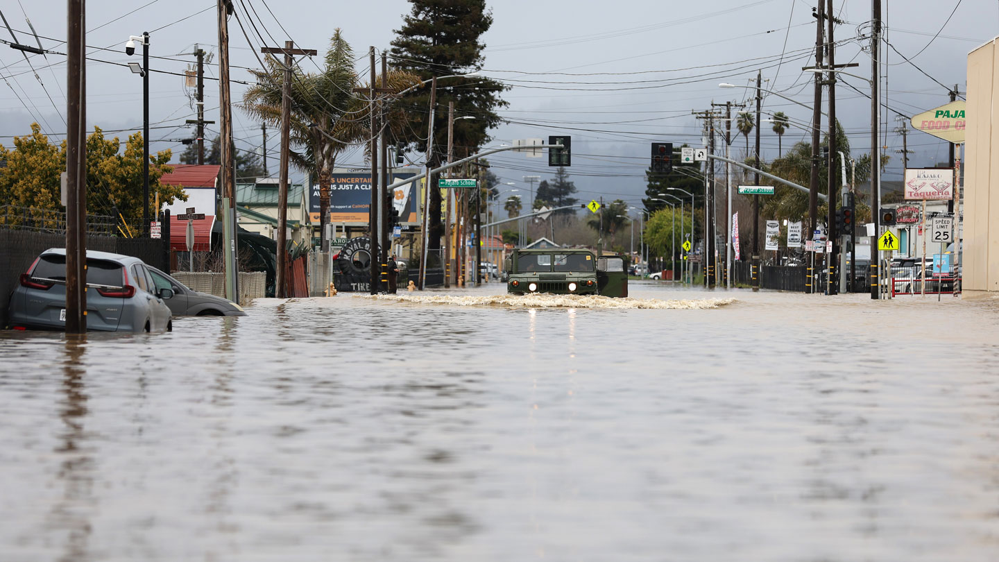
That was hammered home from December 2022 into early 2023. During this period, a seemingly relentless barrage of atmospheric rivers hit the U.S. and Canadian West Coasts. Just in December and January, nine atmospheric rivers slammed the area back to back. More than 121 billion metric tons (133 billion U.S. short tons) of water fell on California alone. That’s enough water to fill 48.4 million Olympic-size swimming pools!
Yet big as they are, these storms can be surprisingly tough to see coming. A week’s warning is about the best that forecasters can now give.
But Ralph and others are working to change that.
Studying those high-flying rivers
Ten years ago, Ralph was part of a team at Scripps that created the Center for Western Weather and Water Extremes, or CW3E for short. Today Ralph directs this center.
It created the first computer model tailored to predict atmospheric rivers on the U.S. West Coast. This year, his team created an atmospheric-river-intensity scale. It ranks storm events based on their size and how much water they carry.
Satellites also provide valuable data over the ocean. But they generally can’t see through clouds and heavy rains or snow — major features of atmospheric rivers. And atmospheric rivers hang low in the lowest part of Earth’s atmosphere. That makes it even harder for satellites to spy on them.
To improve forecasts of landfall and storm intensity, the team turns to data from drifting ocean buoys and weather balloons. Weather balloons have long been the workhorses of weather prediction. But they’re launched over land. Ideally, says Anna Wilson, scientists want “to see what happens before [an atmospheric river] makes landfall.”
Wilson is a Scripps atmospheric scientist who manages field research for CW3E. Her group has turned to airplanes to fill the data gap. It has even enlisted the aid of the U.S. Air Force’s hurricane hunters for their aerial surveys.
During each mission, the planes drop instruments. Called dropsondes, they collect temperature, moisture, wind and other data as they fall through the air. Since November 1, 2022, the hurricane hunters have flown 39 missions into atmospheric rivers, Wilson reports.
In the U.S. West, atmospheric rivers tend to arrive from January through March. But that’s not really the start of the region’s local atmospheric-river season. Some make landfall in the late fall. One such November 2021 storm devastated the Pacific Northwest by spawning a deadly series of floods and landslides.
Will climate change affect atmospheric rivers?
In recent years, scientists have crunched loads of data as they try to forecast when the next atmospheric river is going to arrive and how intense it will be.
“One thing to keep in mind,” says Ralph, “is that the fuel of an atmospheric river is water vapor. It’s pushed along by the wind.” And those winds, he notes, are driven by the temperature differences between the poles and the equator.
Atmospheric rivers also are being linked to mid-latitude cycles. These form by the collision between cold and warm masses of water in the oceans. Such cyclones can interact with an atmospheric river, perhaps pulling it along. One such fast-forming “bomb cyclone” helped spur on an atmospheric river that drenched California in January 2023.
Predicting atmospheric rivers may become more challenging in coming years. Why? Global warming may be having two opposite effects on atmospheric rivers.
Warmer air can hold more water vapor. That should give the storms more fuel. But the poles are also warming faster than regions near the equator. And that reduces the temperature difference between the regions — an effect that can weaken winds.
But even with weaker winds, Ralph notes, “there are still times when cyclones can form.” And those storms are feeding off an increase in water vapor. That, he says, could mean bigger and longer-lasting atmospheric rivers when they do form.
What’s more, says Wilson, even if climate change doesn’t boost the number of atmospheric rivers, it might still increase their variability. “We may have more frequent shifts between very, very, very wet seasons and very, very, very dry seasons.”
In many parts of the U.S. West, water is already in short supply. Such a seesaw in raininess could make it harder to manage what water there is.
Atmospheric rivers can be a curse or a blessing. They provide up to half of the American West’s annual precipitation. They not only rain on parched farm fields, but also add to the snowpack in the high mountains (whose melting offers another source of freshwater).
The storms in 2023, for instance, did a lot to counter the West’s drought, Ralph says. The landscape has been “greening up” and many smaller reservoirs have refilled.
But “drought is a complicated thing,” he adds. “It will take more wet years like this one to recover” from the many years of drought in California and other parts of the West.


