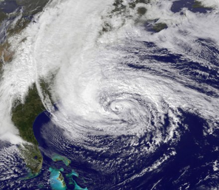
Evolution of a Frankenstorm
Huge, late October hurricane turned into a superstorm that savaged much of the eastern United States
Atlantic City is known for gambling. As bettors would say, Sandy was a long shot, an event that had almost no chance of happening. But in the weeks leading up to Sandy’s landfall, the winds, temperature and humidity shifted in all the right ways to build a freakishly destructive storm.
On October 19, the U.S. National Hurricane Center detected a familiar pattern called a tropical wave drifting over the Caribbean Sea. A tropical wave isn’t in the water; it’s a disturbance in the air that moves from east to west over the Atlantic Ocean. Tropical waves have lower atmospheric pressure than the air around them, and their arrival often brings storms. (As air moves around in the atmosphere, it may pile up in some areas and flow away from others. High-pressure systems, or ridges, contain more air molecules than low-pressure systems.)
Tropical waves in the Caribbean usually peter out. The National Hurricane Center initially concluded that this tropical wave had only a 20 percent chance of growing large enough to become a named storm. But it did grow, probably picking up water vapor from neighboring air. Soon, the winds around the tropical wave began to turn it counterclockwise. The wave gained strength as it pulled energy from the warm sea below. Before long, it became Hurricane Sandy. It dumped heavy rains across islands like Jamaica, the Bahamas and Cuba, killing 69 people in the Caribbean.
The jet stream is a powerful air current that moves west to east across North America. Normally, it should have pushed a hurricane like Sandy away from shore and far out into the Atlantic Ocean. But in late October, the jet stream was blocked by two other weather systems. One was a high-pressure ridge parked over the Atlantic. The other was a low-pressure system that moved in from the northwest.
As Sandy came up from the south, the rotating hurricane merged with the high-pressure ridge. This produced a wet and spinning superstorm, Shuyi Chen told Science News. Chen is a hurricane modeler at the University of Miami. “To me the interesting thing is all the multiple players that are involved — and the odds that are required for them all to be in the same place at the same time.”
As Sandy slowly moved toward the U.S. coast, record-breaking low atmospheric pressures were reported up and down the eastern seaboard. Low pressures usually signify very stormy weather is approaching.
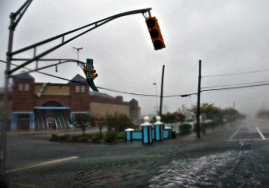
After making landfall, the storm went on to cover some 1.8 million square miles (4.66 million square kilometers) of the United States. Sandy also pushed walls of ocean water, known as storm surges, inland. This led to flooding up and down the mid-Atlantic coast. The resulting winds and other damage knocked out power to more than 8 million households and left homeless tens of thousands of people — mostly in New York and New Jersey.
Sandy’s winds weren’t especially intense. In fact, at its worst, this storm was only a category 2 hurricane on a 5-point scale (with 5 being worst). What made Sandy so destructive was its immense size and sluggish movement. This allowed it to drop huge amounts of rain for days over a gigantic region, weakening the toeholds of trees (so that many toppled) and flooding streams.
Whether storms as destructive as Sandy will become more common in future years is difficult to predict. Some studies predict that climate change brought on by global warming will bring more intense hurricanes. Still, it’s tough to make a solid connection between global warming and hurricanes. It’s also impossible to blame global warming for any one storm in particular.
Scientists like Chen are looking for lessons in Sandy’s wake. They hope that what they learn will lead to improved predictions in the future.
Power Words
atmospheric pressure The weight of the air molecules above a spot where the pressure is measured.
tropical wave A band of low pressure that, in the North Atlantic Ocean, moves east to west in the tropics. Tropical waves sometimes become major storms like hurricanes.
circulation Movement to and from or around something.
water vapor Droplets of water suspended in the air.
global warming An increase in the average temperature of Earth’s atmosphere, especially a continued increase sufficient to cause climate change.


